Elena geodata
Elena (Cordoba) is a populated place; located in Argentina in America/Argentina/Cordoba (GMT-3) time zone. With population of 2,815 people, there are 567 cities with bigger population in this country. Compared to other cities in Argentina, 57.2% of cities are located further ↑North; 67% of cities are located further →East and 83.1% of cities have lower elevation than Elena. Note1


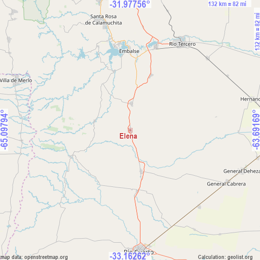
Elena GPS coordinates[2]
32° 34' 19.38" South, 64° 23' 41.316" West
| Map corner | latitude | longitude |
|---|---|---|
| Upper-left | -31.97756°, | -65.09794° |
| Center: | -32.57205°, | -64.39481° |
| Lower-right: | -33.16262°, | -63.69169° |
| Map W x H: | 131.8×131.8 km | = 81.9×81.9mi |
| max Lat: | -21.94467° ⇑57.2% North |
| Elena: | -32.57205° |
| min Lat: | ⇓42.8% South -54.81084° |
| min Long | Elena | max Long |
| -72.88605° | -64.39481° | -53.64581° |
| W 33%⇐ | ⇒67% E |
Elevation
Elevation of Elena is 635 m = 2083 ft, and this is 285.7 m = 937 ft above average elevation for this country.
| Max E: |
4040 m = 13255 ft | 16.9% |
| Elena | 635 m 2083 ft | |
| Avg. | 349.3 m = 1146 ft | |
Min E: |
-2 m = -7 ft | 83.1% |
See also: Argentina elevation on elevation.city.
Geographical zone
Elena is located in South temperate zone (between Tropic of Capricorn and the Antarctic Circle). Distance of this Southern Tropic circle is 1015.8 km =631.2 mi to North.| Distance of | km | miles | from Elena |
|---|---|---|---|
| Equator | 3621.7 | 2250.4 | to North |
| Tropic Capricorn | 1015.8 | 631.2 | to North |
| Antarctic Circle | 3779.5 | 2348.5 | to South |
| South Pole | 6385.4 | 3967.7 | to South |


Nearby cities:
15 places around Elena: (largest is in red/bold)
• Almafuerte
44.1 km =27.4 mi,  17°
17°
• Berrotarán
13.5 km =8.4 mi,  2°
2°
• Carnerillo
51.6 km =32.1 mi,  137°
137°
• Charras
59.8 km =37.2 mi,  147°
147°
• Coronel Baigorria
30.8 km =19.1 mi,  174°
174°
• Embalse
43.6 km =27.1 mi,  357°
357°
• General Cabrera
55.7 km =34.6 mi,  118°
118°
• Las Higueras
58.7 km =36.5 mi, 170°
• Los Cóndores
30.1 km =18.7 mi, 21°
• Río Cuarto
62.3 km =38.7 mi,  176°
176°
• Río Tercero
51.6 km =32.1 mi,  30°
30°
• Santa Rosa de Calamuchita
57.5 km =35.7 mi,  346°
346°
• Tancacha
53.4 km =33.2 mi,  46°
46°
• Villa Rumipal
43.5 km =27 mi, 349°
• Villa del Dique
44.3 km =27.5 mi, 352°
Sources, notices
• [Note1] Compared only with cities in Argentina existing in our database
• [Src1] Map data: © OpenStreetMap contributors (CC-BY-SA)
• [Src2] Other city data from geonames.org with taken over terms of usage.
• [Src3] Geographical zone / Annual Mean Temperature by Robert A. Rohde @ Wikipedia
