Carnerillo geodata
Carnerillo (Cordoba) is a populated place; located in Argentina in America/Argentina/Cordoba (GMT-3) time zone. With population of 1,575 people, there are 687 cities with bigger population in this country. Compared to other cities in Argentina, 60.9% of cities are located further ↑North; 61.5% of cities are located further →East and 68.4% of cities have lower elevation than Carnerillo. Note1


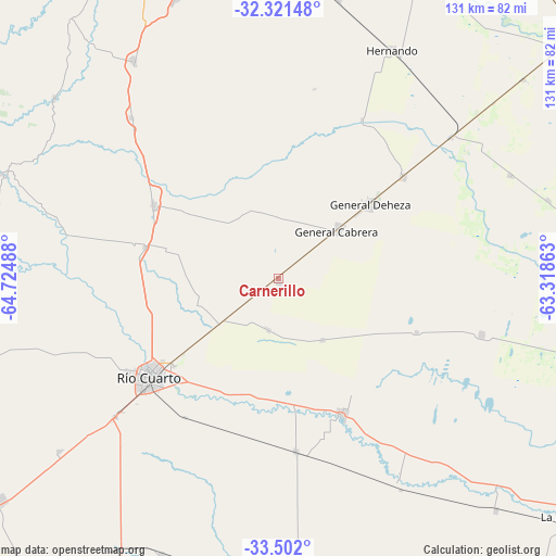
Carnerillo GPS coordinates[2]
32° 54' 49.356" South, 64° 1' 18.3" West
| Map corner | latitude | longitude |
|---|---|---|
| Upper-left | -32.32148°, | -64.72488° |
| Center: | -32.91371°, | -64.02175° |
| Lower-right: | -33.502°, | -63.31863° |
| Map W x H: | 131.3×131.3 km | = 81.6×81.6mi |
| max Lat: | -21.94467° ⇑60.9% North |
| Carnerillo: | -32.91371° |
| min Lat: | ⇓39.1% South -54.81084° |
| min Long | Carnerillo | max Long |
| -72.88605° | -64.02175° | -53.64581° |
| W 38.5%⇐ | ⇒61.5% E |
Elevation
Elevation of Carnerillo is 322 m = 1056 ft, and this is 27.3 m = 90 ft below average elevation for this country.
| Max E: |
4040 m = 13255 ft | 31.6% |
| Avg. | 349.3 m = 1146 ft | |
| Carnerillo | 322 m = 1056 ft | |
Min E: |
-2 m = -7 ft | 68.4% |
See also: Argentina elevation on elevation.city.
Geographical zone
Carnerillo is located in South temperate zone (between Tropic of Capricorn and the Antarctic Circle). Distance of this Southern Tropic circle is 1053.7 km =654.7 mi to North.| Distance of | km | miles | from Carnerillo |
|---|---|---|---|
| Equator | 3659.7 | 2274 | to North |
| Tropic Capricorn | 1053.7 | 654.7 | to North |
| Antarctic Circle | 3741.5 | 2324.9 | to South |
| South Pole | 6347.4 | 3944.1 | to South |


Nearby cities:
15 places around Carnerillo: (largest is in red/bold)
• Alejandro Roca
56.5 km =35.1 mi,  150°
150°
• Berrotarán
61.9 km =38.5 mi,  326°
326°
• Charras
12.5 km =7.8 mi,  190°
190°
• Coronel Baigorria
32.5 km =20.2 mi,  283°
283°
• Dalmacio Vélez Sársfield
53.3 km =33.1 mi,  50°
50°
• Elena
51.6 km =32.1 mi,  317°
317°
• General Cabrera
17.9 km =11.1 mi, 51°
• Hernando
60.5 km =37.6 mi,  26°
26°
• Las Acequias
41.1 km =25.5 mi,  174°
174°
• Las Higueras
31.9 km =19.8 mi,  231°
231°
• Las Perdices
38 km =23.6 mi, 50°
• Río Cuarto
39 km =24.2 mi, 231°
• Ticino
60 km =37.3 mi,  65°
65°
• Ucacha
49.8 km =30.9 mi,  105°
105°
• Villa Reducción
35.2 km =21.9 mi,  155°
155°
Sources, notices
• [Note1] Compared only with cities in Argentina existing in our database
• [Src1] Map data: © OpenStreetMap contributors (CC-BY-SA)
• [Src2] Other city data from geonames.org with taken over terms of usage.
• [Src3] Geographical zone / Annual Mean Temperature by Robert A. Rohde @ Wikipedia
