Bernardo Larroudé geodata
Bernardo Larroudé (La Pampa) is a populated place; located in Argentina in America/Argentina/Salta (GMT-3) time zone. With population of 1,619 people, there are 680 cities with bigger population in this country. Compared to other cities in Argentina, 77.6% of cities are located further ↑North; 56.6% of cities are located further →East and 54% of cities have higher elevation than Bernardo Larroudé. Note1


Bernardo Larroudé GPS coordinates[2]
35° 1' 28.164" South, 63° 34' 57.108" West
| Map corner | latitude | longitude |
|---|---|---|
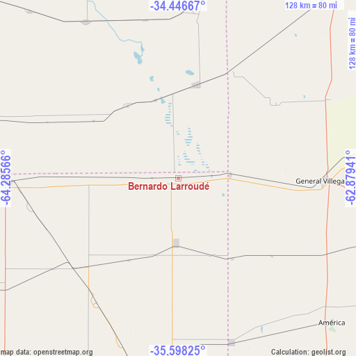
| Upper-left | -34.44667°, | -64.28566° |
| Center: | -35.02449°, | -63.58253° |
| Lower-right: | -35.59825°, | -62.87941° |
| Map W x H: | 128×128 km | = 79.5×79.5mi |
| max Lat: | -21.94467° ⇑77.6% North |
| Bernardo Larroudé: | -35.02449° |
| min Lat: | ⇓22.4% South -54.81084° |
| min Long | Bernardo Larrou | max Long |
| -72.88605° | -63.58253° | -53.64581° |
| W 43.4%⇐ | ⇒56.6% E |
Elevation
Elevation of Bernardo Larroudé is 127 m = 417 ft, and this is 222.3 m = 729 ft below average elevation for this country.
| Max E: |
4040 m = 13255 ft | 54% |
| Avg. | 349.3 m = 1146 ft | |
| Bernardo Larroudé | 127 m = 417 ft | |
Min E: |
-2 m = -7 ft | 46% |
See also: Argentina elevation on elevation.city.
Geographical zone
Bernardo Larroudé is located in South temperate zone (between Tropic of Capricorn and the Antarctic Circle). Distance of this Southern Tropic circle is 1288.4 km =800.6 mi to North.| Distance of | km | miles | from Bernardo Larroudé |
|---|---|---|---|
| Equator | 3894.4 | 2419.9 | to North |
| Tropic Capricorn | 1288.4 | 800.6 | to North |
| Antarctic Circle | 3506.8 | 2179 | to South |
| South Pole | 6112.7 | 3798.3 | to South |


Nearby cities:
15 places around Bernardo Larroudé: (largest is in red/bold)
• Alta Italia
59.3 km =36.8 mi,  234°
234°
• Buchardo
34.2 km =21.3 mi,  11°
11°
• Embajador Martini
75.1 km =46.7 mi,  237°
237°
• General Pico
72 km =44.7 mi,  192°
192°
• General Villegas
51.9 km =32.2 mi,  91°
91°
• Huinca Renancó
75.2 km =46.7 mi,  285°
285°
• Ingeniero Luiggi
89.7 km =55.7 mi, 243°
• Intendente Alvear
23.3 km =14.5 mi,  182°
182°
• Italó
31.6 km =19.6 mi,  324°
324°
• Mattaldi
80.9 km =50.3 mi, 318°
• Parera
84.6 km =52.6 mi,  260°
260°
• Realicó
60.3 km =37.5 mi,  268°
268°
• Santa Magdalena
65.3 km =40.6 mi,  329°
329°
• Serrano
61.8 km =38.4 mi,  3°
3°
• Tres Algarrobos
75.9 km =47.2 mi,  104°
104°
Sources, notices
• [Note1] Compared only with cities in Argentina existing in our database
• [Src1] Map data: © OpenStreetMap contributors (CC-BY-SA)
• [Src2] Other city data from geonames.org with taken over terms of usage.
• [Src3] Geographical zone / Annual Mean Temperature by Robert A. Rohde @ Wikipedia
