Puchen geodata
Puchen (Styria) is a populated place; located in Austria in Europe/Vienna (GMT+2) time zone. With population of 551 people, there are 2316 cities with bigger population in this country. Compared to other cities in Austria, 51.5% of cities are located further ↓South; 70.1% of cities are located further →East and 80.4% of cities have lower elevation than Puchen. Note1


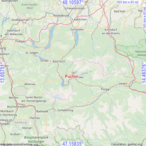
Puchen GPS coordinates[2]
47° 38' 3.516" North, 13° 45' 38.268" East
| Map corner | latitude | longitude |
|---|---|---|
| Upper-left | 48.10597°, | 13.05751° |
| Center: | 47.63431°, | 13.76063° |
| Lower-right: | 47.15835°, | 14.46376° |
| Map W x H: | 105.4×105.4 km | = 65.5×65.5mi |
| max Lat: | 48.98333° ⇑48.5% North |
| Puchen: | 47.63431° |
| min Lat: | ⇓51.5% South 46.48841° |
| min Long | Puchen | max Long |
| 9.57802° | 13.76063° | 17.1° |
| W 29.9%⇐ | ⇒70.1% E |
Elevation
Elevation of Puchen is 726 m = 2382 ft, and this is 220.5 m = 723 ft above average elevation for this country.
| Max E: |
2140 m = 7021 ft | 19.6% |
| Puchen | 726 m 2382 ft | |
| Avg. | 505.5 m = 1658 ft | |
Min E: |
118 m = 387 ft | 80.4% |
See also: Austria elevation on elevation.city.
Geographical zone
Puchen is located in North temperate zone (between Tropic of Cancer and the Arctic Circle). Distance of this North polar circle is 2104.7 km =1307.8 mi to North.| Distance of | km | miles | from Puchen |
|---|---|---|---|
| North Pole | 4710.6 | 2927 | to North |
| Arctic Circle | 2104.7 | 1307.8 | to North |
| Tropic Cancer | 2690.5 | 1671.8 | to South |
| Equator | 5296.4 | 3291 | to South |


Nearby cities:
15 places around Puchen: (largest is in red/bold)
• Altaussee
0.5 km =0.3 mi,  19°
19°
• Bad Aussee
3.2 km =2 mi,  148°
148°
• Bad Goisern
10.9 km =6.8 mi,  274°
274°
• Bad Ischl
13.6 km =8.5 mi,  308°
308°
• Gschwandt
10.7 km =6.6 mi, 268°
• Jainzen
14.1 km =8.8 mi, 310°
• Kaltenbach
13.9 km =8.6 mi, 305°
• Lerchenreith
3 km =1.9 mi,  170°
170°
• Obertraun
10.2 km =6.3 mi,  213°
213°
• Obertressen
2.6 km =1.6 mi,  139°
139°
• Reiterndorf
12.5 km =7.8 mi, 308°
• Rettenbach
13.1 km =8.1 mi,  324°
324°
• Steinfeld
12.9 km =8 mi, 312°
• Sulzbach
12.6 km =7.8 mi,  302°
302°
• Untersee
8.5 km =5.3 mi,  256°
256°
Sources, notices
• [Note1] Compared only with cities in Austria existing in our database
• [Src1] Map data: © OpenStreetMap contributors (CC-BY-SA)
• [Src2] Other city data from geonames.org with taken over terms of usage.
• [Src3] Geographical zone / Annual Mean Temperature by Robert A. Rohde @ Wikipedia
