Zöbern geodata
Zöbern (Lower Austria) is a seat of a third-order administrative division; located in Austria in Europe/Vienna (GMT+2) time zone. With population of 729 people, there are 1775 cities with bigger population in this country. Compared to other cities in Austria, 53.1% of cities are located further ↑North; 84.2% of cities are located further ←West and 73.3% of cities have lower elevation than Zöbern. Note1
Administrative division(s):
- Level 1: Lower Austria
- Level 2: Politischer Bezirk Neunkirchen
- Level 3: Zöbern


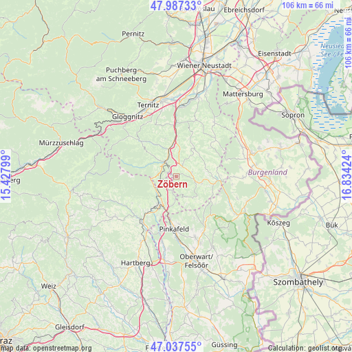
Zöbern GPS coordinates[2]
47° 30' 52.524" North, 16° 7' 51.996" East
| Map corner | latitude | longitude |
|---|---|---|
| Upper-left | 47.98733°, | 15.42799° |
| Center: | 47.51459°, | 16.13111° |
| Lower-right: | 47.03755°, | 16.83424° |
| Map W x H: | 105.6×105.6 km | = 65.6×65.6mi |
| max Lat: | 48.98333° ⇑53.1% North |
| Zöbern: | 47.51459° |
| min Lat: | ⇓46.9% South 46.48841° |
| min Long | Zöbern | max Long |
| 9.57802° | 16.13111° | 17.1° |
| W 84.2%⇐ | ⇒15.8% E |
Elevation
Elevation of Zöbern is 630 m = 2067 ft, and this is 124.5 m = 408 ft above average elevation for this country.
| Max E: |
2140 m = 7021 ft | 26.7% |
| Zöbern | 630 m 2067 ft | |
| Avg. | 505.5 m = 1658 ft | |
Min E: |
118 m = 387 ft | 73.3% |
See also: Austria elevation on elevation.city.
Geographical zone
Zöbern is located in North temperate zone (between Tropic of Cancer and the Arctic Circle). Distance of this North polar circle is 2118 km =1316.1 mi to North.| Distance of | km | miles | from Zöbern |
|---|---|---|---|
| North Pole | 4723.9 | 2935.3 | to North |
| Arctic Circle | 2118 | 1316.1 | to North |
| Tropic Cancer | 2677.2 | 1663.5 | to South |
| Equator | 5283.1 | 3282.8 | to South |


Nearby cities:
15 places around Zöbern: (largest is in red/bold)
• Aspang Markt
5.3 km =3.3 mi,  317°
317°
• Bad Schönau
8 km =5 mi,  105°
105°
• Edlitz
9.3 km =5.8 mi,  4°
4°
• Feistritz am Wechsel
11.3 km =7 mi,  327°
327°
• Friedberg
10.9 km =6.8 mi,  214°
214°
• Grimmenstein
11.3 km =7 mi,  358°
358°
• Krumbach Markt
3.9 km =2.4 mi,  86°
86°
• Königsberg
7.4 km =4.6 mi, 0°
• Lichtenegg
10.8 km =6.7 mi,  28°
28°
• Mönichkirchen
7.3 km =4.5 mi,  266°
266°
• Ortgraben
9.4 km =5.8 mi,  220°
220°
• Pinggau
9.4 km =5.8 mi, 210°
• Schäffern
4.4 km =2.7 mi,  201°
201°
• Thomasberg
5.8 km =3.6 mi, 1°
• Tiefenbach
6.6 km =4.1 mi,  69°
69°
Sources, notices
• [Note1] Compared only with cities in Austria existing in our database
• [Src1] Map data: © OpenStreetMap contributors (CC-BY-SA)
• [Src2] Other city data from geonames.org with taken over terms of usage.
• [Src3] Geographical zone / Annual Mean Temperature by Robert A. Rohde @ Wikipedia
