Grimmenstein geodata
Grimmenstein (Lower Austria) is a seat of a third-order administrative division; located in Austria in Europe/Vienna (GMT+2) time zone. With population of 953 people, there are 1357 cities with bigger population in this country. Compared to other cities in Austria, 51% of cities are located further ↓South; 84.1% of cities are located further ←West and 57.2% of cities have higher elevation than Grimmenstein. Note1
Administrative division(s):
- Level 1: Lower Austria
- Level 2: Politischer Bezirk Neunkirchen
- Level 3: Grimmenstein


Grimmenstein GPS coordinates[2]
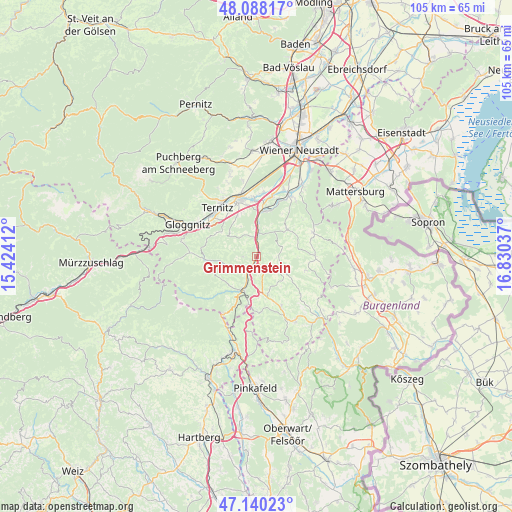
47° 36' 58.86" North, 16° 7' 38.064" East
| Map corner | latitude | longitude |
|---|---|---|
| Upper-left | 48.08817°, | 15.42412° |
| Center: | 47.61635°, | 16.12724° |
| Lower-right: | 47.14023°, | 16.83037° |
| Map W x H: | 105.4×105.4 km | = 65.5×65.5mi |
| max Lat: | 48.98333° ⇑49% North |
| Grimmenstein: | 47.61635° |
| min Lat: | ⇓51% South 46.48841° |
| min Long | Grimmenstein | max Long |
| 9.57802° | 16.12724° | 17.1° |
| W 84.1%⇐ | ⇒15.9% E |
Elevation
Elevation of Grimmenstein is 404 m = 1325 ft, and this is 101.5 m = 333 ft below average elevation for this country.
| Max E: |
2140 m = 7021 ft | 57.2% |
| Avg. | 505.5 m = 1658 ft | |
| Grimmenstein | 404 m = 1325 ft | |
Min E: |
118 m = 387 ft | 42.8% |
See also: Austria elevation on elevation.city.
Geographical zone
Grimmenstein is located in North temperate zone (between Tropic of Cancer and the Arctic Circle). Distance of this North polar circle is 2106.7 km =1309 mi to North.| Distance of | km | miles | from Grimmenstein |
|---|---|---|---|
| North Pole | 4712.6 | 2928.3 | to North |
| Arctic Circle | 2106.7 | 1309 | to North |
| Tropic Cancer | 2688.5 | 1670.6 | to South |
| Equator | 5294.4 | 3289.8 | to South |


Nearby cities:
15 places around Grimmenstein: (largest is in red/bold)
• Altendorf
9.1 km =5.7 mi,  294°
294°
• Aspang Markt
8.1 km =5 mi,  204°
204°
• Bromberg
8.3 km =5.2 mi,  48°
48°
• Edlitz
2.3 km =1.4 mi,  154°
154°
• Feistritz am Wechsel
6.1 km =3.8 mi,  252°
252°
• Königsberg
4 km =2.5 mi,  174°
174°
• Lichtenegg
5.7 km =3.5 mi,  108°
108°
• Sankt Corona am Wechsel
10.2 km =6.3 mi, 248°
• Scheiblingkirchen
5.1 km =3.2 mi,  6°
6°
• Schlatten
9.9 km =6.2 mi,  67°
67°
• Seebenstein
9.3 km =5.8 mi, 8°
• Thernberg
5.6 km =3.5 mi, 48°
• Thomasberg
5.5 km =3.4 mi,  175°
175°
• Warth
3.8 km =2.4 mi,  348°
348°
• Wartmannstetten
9.4 km =5.8 mi,  335°
335°
Sources, notices
• [Note1] Compared only with cities in Austria existing in our database
• [Src1] Map data: © OpenStreetMap contributors (CC-BY-SA)
• [Src2] Other city data from geonames.org with taken over terms of usage.
• [Src3] Geographical zone / Annual Mean Temperature by Robert A. Rohde @ Wikipedia
