Pinggau geodata
Pinggau (Styria) is a seat of a third-order administrative division; located in Austria in Europe/Vienna (GMT+2) time zone. With population of 1,338 people, there are 944 cities with bigger population in this country. Compared to other cities in Austria, 57.2% of cities are located further ↑North; 82.1% of cities are located further ←West and 70.8% of cities have lower elevation than Pinggau. Note1
Administrative division(s):
- Level 1: Styria
- Level 2: Politischer Bezirk Hartberg-Fürstenfeld
- Level 3: Pinggau


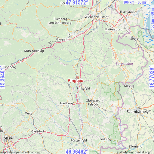
Pinggau GPS coordinates[2]
47° 26' 32.352" North, 16° 4' 1.668" East
| Map corner | latitude | longitude |
|---|---|---|
| Upper-left | 47.91572°, | 15.36401° |
| Center: | 47.44232°, | 16.06713° |
| Lower-right: | 46.96462°, | 16.77026° |
| Map W x H: | 105.8×105.8 km | = 65.7×65.7mi |
| max Lat: | 48.98333° ⇑57.2% North |
| Pinggau: | 47.44232° |
| min Lat: | ⇓42.8% South 46.48841° |
| min Long | Pinggau | max Long |
| 9.57802° | 16.06713° | 17.1° |
| W 82.1%⇐ | ⇒17.9% E |
Elevation
Elevation of Pinggau is 597 m = 1959 ft, and this is 91.5 m = 300 ft above average elevation for this country.
| Max E: |
2140 m = 7021 ft | 29.2% |
| Pinggau | 597 m 1959 ft | |
| Avg. | 505.5 m = 1658 ft | |
Min E: |
118 m = 387 ft | 70.8% |
See also: Austria elevation on elevation.city.
Geographical zone
Pinggau is located in North temperate zone (between Tropic of Cancer and the Arctic Circle). Distance of this North polar circle is 2126.1 km =1321.1 mi to North.| Distance of | km | miles | from Pinggau |
|---|---|---|---|
| North Pole | 4732 | 2940.3 | to North |
| Arctic Circle | 2126.1 | 1321.1 | to North |
| Tropic Cancer | 2669.2 | 1658.6 | to South |
| Equator | 5275.1 | 3277.8 | to South |


Nearby cities:
15 places around Pinggau: (largest is in red/bold)
• Dechantskirchen
4.7 km =2.9 mi,  233°
233°
• Ehrenschachen
3.9 km =2.4 mi,  194°
194°
• Eichberg
9.7 km =6 mi, 226°
• Friedberg
1.6 km =1 mi, 232°
• Grafenschachen
8.4 km =5.2 mi,  180°
180°
• Lafnitz
9.3 km =5.8 mi,  207°
207°
• Mönichkirchen
8 km =5 mi,  341°
341°
• Neustift an der Lafnitz
8.8 km =5.5 mi,  196°
196°
• Ortgraben
1.5 km =0.9 mi,  303°
303°
• Pinkafeld
9.2 km =5.7 mi,  156°
156°
• Rohrbach an der Lafnitz
8.3 km =5.2 mi,  217°
217°
• Sankt Lorenzen am Wechsel
8.4 km =5.2 mi,  269°
269°
• Schäffern
5.1 km =3.2 mi,  39°
39°
• Wiesfleck
8.7 km =5.4 mi,  137°
137°
• Zöbern
9.4 km =5.8 mi,  30°
30°
Sources, notices
• [Note1] Compared only with cities in Austria existing in our database
• [Src1] Map data: © OpenStreetMap contributors (CC-BY-SA)
• [Src2] Other city data from geonames.org with taken over terms of usage.
• [Src3] Geographical zone / Annual Mean Temperature by Robert A. Rohde @ Wikipedia
