Tiefenbach geodata
Tiefenbach (Lower Austria) is a seat of a third-order administrative division; located in Austria in Europe/Vienna (GMT+2) time zone. With population of 25 people, there are 2948 cities with bigger population in this country. Compared to other cities in Austria, 52% of cities are located further ↑North; 86.3% of cities are located further ←West and 64% of cities have lower elevation than Tiefenbach. Note1
Administrative division(s):
- Level 1: Lower Austria
- Level 2: Politischer Bezirk Wiener Neustadt
- Level 3: Lichtenegg


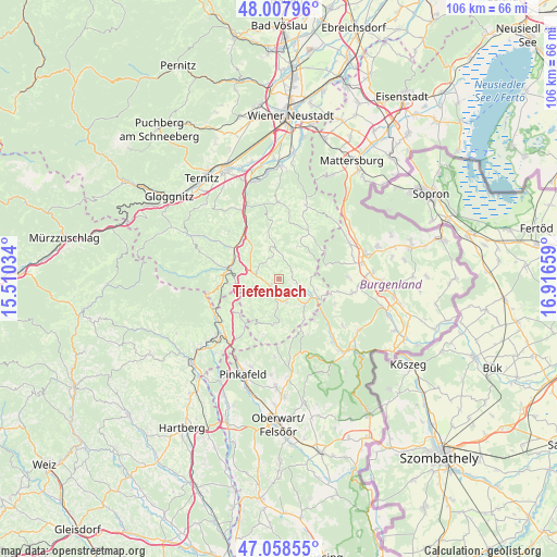
Tiefenbach GPS coordinates[2]
47° 32' 7.44" North, 16° 12' 48.456" East
| Map corner | latitude | longitude |
|---|---|---|
| Upper-left | 48.00796°, | 15.51034° |
| Center: | 47.5354°, | 16.21346° |
| Lower-right: | 47.05855°, | 16.91659° |
| Map W x H: | 105.6×105.6 km | = 65.6×65.6mi |
| max Lat: | 48.98333° ⇑52% North |
| Tiefenbach: | 47.5354° |
| min Lat: | ⇓48% South 46.48841° |
| min Long | Tiefenbach | max Long |
| 9.57802° | 16.21346° | 17.1° |
| W 86.3%⇐ | ⇒13.7% E |
Elevation
Elevation of Tiefenbach is 545 m = 1788 ft, and this is 39.5 m = 130 ft above average elevation for this country.
| Max E: |
2140 m = 7021 ft | 36% |
| Tiefenbach | 545 m 1788 ft | |
| Avg. | 505.5 m = 1658 ft | |
Min E: |
118 m = 387 ft | 64% |
See also: Austria elevation on elevation.city.
Geographical zone
Tiefenbach is located in North temperate zone (between Tropic of Cancer and the Arctic Circle). Distance of this North polar circle is 2115.7 km =1314.6 mi to North.| Distance of | km | miles | from Tiefenbach |
|---|---|---|---|
| North Pole | 4721.6 | 2933.9 | to North |
| Arctic Circle | 2115.7 | 1314.6 | to North |
| Tropic Cancer | 2679.5 | 1665 | to South |
| Equator | 5285.4 | 3284.2 | to South |


Nearby cities:
15 places around Tiefenbach: (largest is in red/bold)
• Aspang Markt
9.9 km =6.2 mi,  279°
279°
• Bad Schönau
4.8 km =3 mi,  161°
161°
• Edlitz
8.9 km =5.5 mi,  321°
321°
• Grimmenstein
11.1 km =6.9 mi, 324°
• Hollenthon
7 km =4.3 mi,  30°
30°
• Kirchschlag in der Buckligen Welt
6.6 km =4.1 mi,  126°
126°
• Krumbach Markt
3.1 km =1.9 mi,  227°
227°
• Königsberg
7.9 km =4.9 mi,  309°
309°
• Lichtenegg
7.3 km =4.5 mi,  351°
351°
• Schäffern
10.1 km =6.3 mi, 230°
• Thernberg
12.9 km =8 mi, 349°
• Thomasberg
6.9 km =4.3 mi,  300°
300°
• Weingraben
11.5 km =7.1 mi,  101°
101°
• Wiesmath
10.4 km =6.5 mi, 30°
• Zöbern
6.6 km =4.1 mi,  249°
249°
Sources, notices
• [Note1] Compared only with cities in Austria existing in our database
• [Src1] Map data: © OpenStreetMap contributors (CC-BY-SA)
• [Src2] Other city data from geonames.org with taken over terms of usage.
• [Src3] Geographical zone / Annual Mean Temperature by Robert A. Rohde @ Wikipedia
