Zagersdorf geodata
Zagersdorf (Burgenland) is a seat of a third-order administrative division; located in Austria in Europe/Vienna (GMT+2) time zone. With population of 1,027 people, there are 1249 cities with bigger population in this country. Compared to other cities in Austria, 55.8% of cities are located further ↓South; 94.2% of cities are located further ←West and 95.1% of cities have higher elevation than Zagersdorf. Note1


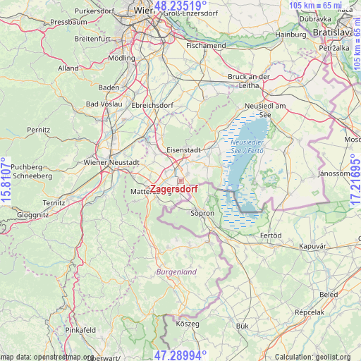
Zagersdorf GPS coordinates[2]
47° 45' 52.956" North, 16° 30' 49.752" East
| Map corner | latitude | longitude |
|---|---|---|
| Upper-left | 48.23519°, | 15.8107° |
| Center: | 47.76471°, | 16.51382° |
| Lower-right: | 47.28994°, | 17.21695° |
| Map W x H: | 105.1×105.1 km | = 65.3×65.3mi |
| max Lat: | 48.98333° ⇑44.2% North |
| Zagersdorf: | 47.76471° |
| min Lat: | ⇓55.8% South 46.48841° |
| min Long | Zagersdorf | max Long |
| 9.57802° | 16.51382° | 17.1° |
| W 94.2%⇐ | ⇒5.8% E |
Elevation
Elevation of Zagersdorf is 179 m = 587 ft, and this is 326.5 m = 1071 ft below average elevation for this country.
| Max E: |
2140 m = 7021 ft | 95.1% |
| Avg. | 505.5 m = 1658 ft | |
| Zagersdorf | 179 m = 587 ft | |
Min E: |
118 m = 387 ft | 4.9% |
See also: Austria elevation on elevation.city.
Geographical zone
Zagersdorf is located in North temperate zone (between Tropic of Cancer and the Arctic Circle). Distance of this North polar circle is 2090.2 km =1298.8 mi to North.| Distance of | km | miles | from Zagersdorf |
|---|---|---|---|
| North Pole | 4696.1 | 2918 | to North |
| Arctic Circle | 2090.2 | 1298.8 | to North |
| Tropic Cancer | 2705 | 1680.8 | to South |
| Equator | 5310.9 | 3300 | to South |


Nearby cities:
15 places around Zagersdorf: (largest is in red/bold)
• Antau
2.7 km =1.7 mi,  291°
291°
• Baumgarten im Burgenland
3 km =1.9 mi,  199°
199°
• Drassburg
2.9 km =1.8 mi,  224°
224°
• Hirm
5 km =3.1 mi,  298°
298°
• Klingenbach
2.5 km =1.6 mi,  125°
125°
• Krensdorf
7.7 km =4.8 mi, 287°
• Loipersbach im Burgenland
8 km =5 mi, 198°
• Pöttelsdorf
5.8 km =3.6 mi,  257°
257°
• Schattendorf
6.1 km =3.8 mi,  182°
182°
• Siegendorf im Burgenland
2.8 km =1.7 mi,  49°
49°
• Stöttera
4 km =2.5 mi,  275°
275°
• Trausdorf an der Wulka
6.3 km =3.9 mi,  31°
31°
• Walbersdorf
7.4 km =4.6 mi,  250°
250°
• Wulkaprodersdorf
3.7 km =2.3 mi,  349°
349°
• Zemendorf
4.7 km =2.9 mi,  267°
267°
Sources, notices
• [Note1] Compared only with cities in Austria existing in our database
• [Src1] Map data: © OpenStreetMap contributors (CC-BY-SA)
• [Src2] Other city data from geonames.org with taken over terms of usage.
• [Src3] Geographical zone / Annual Mean Temperature by Robert A. Rohde @ Wikipedia
