Drassburg geodata
Drassburg (Burgenland) is a populated place; located in Austria in Europe/Vienna (GMT+2) time zone. With population of 1,199 people, there are 1047 cities with bigger population in this country. Compared to other cities in Austria, 55.4% of cities are located further ↓South; 93.6% of cities are located further ←West and 87.4% of cities have higher elevation than Drassburg. Note1
Administrative division(s):
- Level 1: Burgenland
- Level 2: Politischer Bezirk Mattersburg
- Level 3: Draßburg


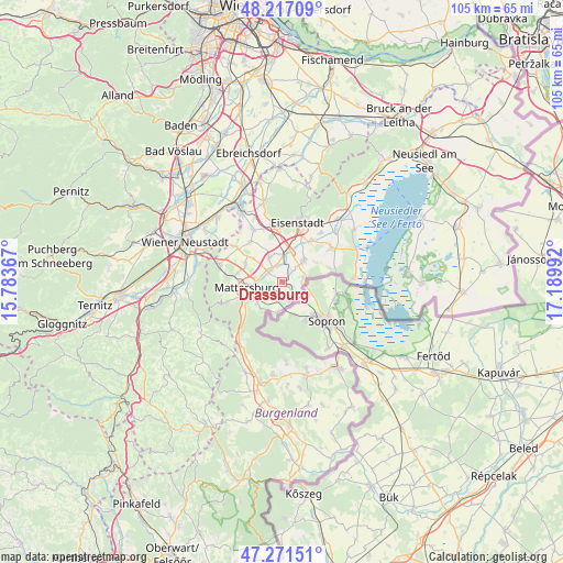
Drassburg GPS coordinates[2]
47° 44' 47.22" North, 16° 29' 12.444" East
| Map corner | latitude | longitude |
|---|---|---|
| Upper-left | 48.21709°, | 15.78367° |
| Center: | 47.74645°, | 16.48679° |
| Lower-right: | 47.27151°, | 17.18992° |
| Map W x H: | 105.1×105.1 km | = 65.3×65.3mi |
| max Lat: | 48.98333° ⇑44.6% North |
| Drassburg: | 47.74645° |
| min Lat: | ⇓55.4% South 46.48841° |
| min Long | Drassburg | max Long |
| 9.57802° | 16.48679° | 17.1° |
| W 93.6%⇐ | ⇒6.4% E |
Elevation
Elevation of Drassburg is 233 m = 764 ft, and this is 272.5 m = 894 ft below average elevation for this country.
| Max E: |
2140 m = 7021 ft | 87.4% |
| Avg. | 505.5 m = 1658 ft | |
| Drassburg | 233 m = 764 ft | |
Min E: |
118 m = 387 ft | 12.6% |
See also: Austria elevation on elevation.city.
Geographical zone
Drassburg is located in North temperate zone (between Tropic of Cancer and the Arctic Circle). Distance of this North polar circle is 2092.3 km =1300.1 mi to North.| Distance of | km | miles | from Drassburg |
|---|---|---|---|
| North Pole | 4698.2 | 2919.3 | to North |
| Arctic Circle | 2092.3 | 1300.1 | to North |
| Tropic Cancer | 2703 | 1679.6 | to South |
| Equator | 5308.9 | 3298.8 | to South |


Nearby cities:
15 places around Drassburg: (largest is in red/bold)
• Antau
3.1 km =1.9 mi,  350°
350°
• Baumgarten im Burgenland
1.3 km =0.8 mi,  129°
129°
• Hirm
5.1 km =3.2 mi,  331°
331°
• Klingenbach
4.1 km =2.5 mi,  81°
81°
• Loipersbach im Burgenland
5.6 km =3.5 mi,  185°
185°
• Marz
6.2 km =3.9 mi,  237°
237°
• Pöttelsdorf
3.7 km =2.3 mi,  282°
282°
• Rohrbach bei Mattersburg
6.2 km =3.9 mi,  222°
222°
• Schattendorf
4.4 km =2.7 mi,  157°
157°
• Siegendorf im Burgenland
5.7 km =3.5 mi,  47°
47°
• Stöttera
3.1 km =1.9 mi,  321°
321°
• Walbersdorf
5 km =3.1 mi,  264°
264°
• Wulkaprodersdorf
5.8 km =3.6 mi,  13°
13°
• Zagersdorf
2.9 km =1.8 mi,  44°
44°
• Zemendorf
3.2 km =2 mi,  304°
304°
Sources, notices
• [Note1] Compared only with cities in Austria existing in our database
• [Src1] Map data: © OpenStreetMap contributors (CC-BY-SA)
• [Src2] Other city data from geonames.org with taken over terms of usage.
• [Src3] Geographical zone / Annual Mean Temperature by Robert A. Rohde @ Wikipedia
