Antau geodata
Antau (Burgenland) is a seat of a third-order administrative division; located in Austria in Europe/Vienna (GMT+2) time zone. With population of 758 people, there are 1710 cities with bigger population in this country. Compared to other cities in Austria, 56.1% of cities are located further ↓South; 93.3% of cities are located further ←West and 94% of cities have higher elevation than Antau. Note1
Administrative division(s):
- Level 1: Burgenland
- Level 2: Politischer Bezirk Mattersburg
- Level 3: Antau


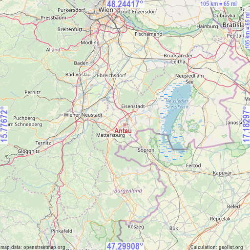
Antau GPS coordinates[2]
47° 46' 25.572" North, 16° 28' 47.424" East
| Map corner | latitude | longitude |
|---|---|---|
| Upper-left | 48.24417°, | 15.77672° |
| Center: | 47.77377°, | 16.47984° |
| Lower-right: | 47.29908°, | 17.18297° |
| Map W x H: | 105.1×105.1 km | = 65.3×65.3mi |
| max Lat: | 48.98333° ⇑43.9% North |
| Antau: | 47.77377° |
| min Lat: | ⇓56.1% South 46.48841° |
| min Long | Antau | max Long |
| 9.57802° | 16.47984° | 17.1° |
| W 93.3%⇐ | ⇒6.7% E |
Elevation
Elevation of Antau is 185 m = 607 ft, and this is 320.5 m = 1052 ft below average elevation for this country.
| Max E: |
2140 m = 7021 ft | 94% |
| Avg. | 505.5 m = 1658 ft | |
| Antau | 185 m = 607 ft | |
Min E: |
118 m = 387 ft | 6% |
See also: Austria elevation on elevation.city.
Geographical zone
Antau is located in North temperate zone (between Tropic of Cancer and the Arctic Circle). Distance of this North polar circle is 2089.2 km =1298.2 mi to North.| Distance of | km | miles | from Antau |
|---|---|---|---|
| North Pole | 4695.1 | 2917.4 | to North |
| Arctic Circle | 2089.2 | 1298.2 | to North |
| Tropic Cancer | 2706 | 1681.4 | to South |
| Equator | 5311.9 | 3300.7 | to South |


Nearby cities:
15 places around Antau: (largest is in red/bold)
• Baumgarten im Burgenland
4.2 km =2.6 mi,  158°
158°
• Drassburg
3.1 km =1.9 mi,  170°
170°
• Grosshöflein
6.9 km =4.3 mi,  0°
0°
• Hirm
2.4 km =1.5 mi,  306°
306°
• Klingenbach
5.2 km =3.2 mi,  118°
118°
• Krensdorf
5 km =3.1 mi,  285°
285°
• Pöttelsdorf
3.8 km =2.4 mi,  234°
234°
• Siegendorf im Burgenland
4.7 km =2.9 mi,  80°
80°
• Sigless
6.3 km =3.9 mi,  271°
271°
• Stöttera
1.5 km =0.9 mi,  245°
245°
• Walbersdorf
5.7 km =3.5 mi, 231°
• Wulkaprodersdorf
3.2 km =2 mi,  34°
34°
• Zagersdorf
2.7 km =1.7 mi,  111°
111°
• Zemendorf
2.5 km =1.6 mi,  240°
240°
• Zillingtal
6.9 km =4.3 mi, 310°
Sources, notices
• [Note1] Compared only with cities in Austria existing in our database
• [Src1] Map data: © OpenStreetMap contributors (CC-BY-SA)
• [Src2] Other city data from geonames.org with taken over terms of usage.
• [Src3] Geographical zone / Annual Mean Temperature by Robert A. Rohde @ Wikipedia
