Wildenau geodata
Wildenau (Upper Austria) is a populated place; located in Austria in Europe/Vienna (GMT+2) time zone. With population of 674 people, there are 1918 cities with bigger population in this country. Compared to other cities in Austria, 79.8% of cities are located further ↓South; 77.5% of cities are located further →East and 55.3% of cities have higher elevation than Wildenau. Note1
Administrative division(s):
- Level 1: Upper Austria
- Level 2: Politischer Bezirk Braunau am Inn
- Level 3: Aspach


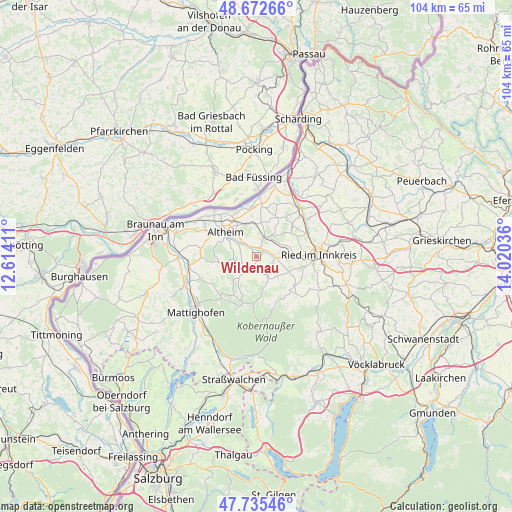
Wildenau GPS coordinates[2]
48° 12' 22.32" North, 13° 19' 2.028" East
| Map corner | latitude | longitude |
|---|---|---|
| Upper-left | 48.67266°, | 12.61411° |
| Center: | 48.2062°, | 13.31723° |
| Lower-right: | 47.73546°, | 14.02036° |
| Map W x H: | 104.2×104.2 km | = 64.7×64.7mi |
| max Lat: | 48.98333° ⇑20.2% North |
| Wildenau: | 48.2062° |
| min Lat: | ⇓79.8% South 46.48841° |
| min Long | Wildenau | max Long |
| 9.57802° | 13.31723° | 17.1° |
| W 22.5%⇐ | ⇒77.5% E |
Elevation
Elevation of Wildenau is 417 m = 1368 ft, and this is 88.5 m = 290 ft below average elevation for this country.
| Max E: |
2140 m = 7021 ft | 55.3% |
| Avg. | 505.5 m = 1658 ft | |
| Wildenau | 417 m = 1368 ft | |
Min E: |
118 m = 387 ft | 44.7% |
See also: Austria elevation on elevation.city.
Geographical zone
Wildenau is located in North temperate zone (between Tropic of Cancer and the Arctic Circle). Distance of this North polar circle is 2041.1 km =1268.3 mi to North.| Distance of | km | miles | from Wildenau |
|---|---|---|---|
| North Pole | 4647 | 2887.5 | to North |
| Arctic Circle | 2041.1 | 1268.3 | to North |
| Tropic Cancer | 2754.1 | 1711.3 | to South |
| Equator | 5360 | 3330.5 | to South |


Nearby cities:
15 places around Wildenau: (largest is in red/bold)
• Altheim
8 km =5 mi,  309°
309°
• Aspach
2.5 km =1.6 mi,  202°
202°
• Aurolzmünster
11.3 km =7 mi,  65°
65°
• Geinberg
6.6 km =4.1 mi,  345°
345°
• Gurten
4.4 km =2.7 mi,  27°
27°
• Lohnsburg
9.5 km =5.9 mi,  136°
136°
• Maria Schmolln
10.5 km =6.5 mi,  223°
223°
• Mehrnbach
8.7 km =5.4 mi,  88°
88°
• Polling im Innkreis
3.9 km =2.4 mi,  315°
315°
• Sankt Georgen bei Obernberg am Inn
9.6 km =6 mi,  7°
7°
• Treubach
7.9 km =4.9 mi,  261°
261°
• Waldzell
11.3 km =7 mi,  133°
133°
• Weilbach
8.9 km =5.5 mi, 27°
• Weng im Innkreis
10.8 km =6.7 mi,  287°
287°
• Wippenham
4.9 km =3 mi, 68°
Sources, notices
• [Note1] Compared only with cities in Austria existing in our database
• [Src1] Map data: © OpenStreetMap contributors (CC-BY-SA)
• [Src2] Other city data from geonames.org with taken over terms of usage.
• [Src3] Geographical zone / Annual Mean Temperature by Robert A. Rohde @ Wikipedia
