Wiesfleck geodata
Wiesfleck (Burgenland) is a seat of a third-order administrative division; located in Austria in Europe/Vienna (GMT+2) time zone. With population of 794 people, there are 1627 cities with bigger population in this country. Compared to other cities in Austria, 60.4% of cities are located further ↑North; 84.7% of cities are located further ←West and 58.8% of cities have higher elevation than Wiesfleck. Note1
Administrative division(s):
- Level 1: Burgenland
- Level 2: Politischer Bezirk Oberwart
- Level 3: Wiesfleck


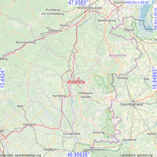
Wiesfleck GPS coordinates[2]
47° 23' 4.488" North, 16° 8' 43.872" East
| Map corner | latitude | longitude |
|---|---|---|
| Upper-left | 47.8585°, | 15.4424° |
| Center: | 47.38458°, | 16.14552° |
| Lower-right: | 46.90636°, | 16.84865° |
| Map W x H: | 105.9×105.9 km | = 65.8×65.8mi |
| max Lat: | 48.98333° ⇑60.4% North |
| Wiesfleck: | 47.38458° |
| min Lat: | ⇓39.6% South 46.48841° |
| min Long | Wiesfleck | max Long |
| 9.57802° | 16.14552° | 17.1° |
| W 84.7%⇐ | ⇒15.3% E |
Elevation
Elevation of Wiesfleck is 393 m = 1289 ft, and this is 112.5 m = 369 ft below average elevation for this country.
| Max E: |
2140 m = 7021 ft | 58.8% |
| Avg. | 505.5 m = 1658 ft | |
| Wiesfleck | 393 m = 1289 ft | |
Min E: |
118 m = 387 ft | 41.2% |
See also: Austria elevation on elevation.city.
Geographical zone
Wiesfleck is located in North temperate zone (between Tropic of Cancer and the Arctic Circle). Distance of this North polar circle is 2132.5 km =1325.1 mi to North.| Distance of | km | miles | from Wiesfleck |
|---|---|---|---|
| North Pole | 4738.4 | 2944.3 | to North |
| Arctic Circle | 2132.5 | 1325.1 | to North |
| Tropic Cancer | 2662.8 | 1654.6 | to South |
| Equator | 5268.7 | 3273.8 | to South |


Nearby cities:
15 places around Wiesfleck: (largest is in red/bold)
• Bad Tatzmannsdorf
8.7 km =5.4 mi,  132°
132°
• Bernstein
8 km =5 mi,  77°
77°
• Buchschachen
8.3 km =5.2 mi,  204°
204°
• Ehrenschachen
7.4 km =4.6 mi,  290°
290°
• Friedberg
9 km =5.6 mi,  307°
307°
• Grafenschachen
6.3 km =3.9 mi,  251°
251°
• Jormannsdorf
6.6 km =4.1 mi, 125°
• Loipersdorf im Burgenland
7.4 km =4.6 mi,  219°
219°
• Mariasdorf
6.8 km =4.2 mi,  107°
107°
• Neustift an der Lafnitz
8.7 km =5.4 mi,  256°
256°
• Oberschützen
5.9 km =3.7 mi, 128°
• Ortgraben
10.2 km =6.3 mi,  315°
315°
• Pinggau
8.7 km =5.4 mi, 317°
• Pinkafeld
2.9 km =1.8 mi,  227°
227°
• Riedlingsdorf
4 km =2.5 mi,  193°
193°
Sources, notices
• [Note1] Compared only with cities in Austria existing in our database
• [Src1] Map data: © OpenStreetMap contributors (CC-BY-SA)
• [Src2] Other city data from geonames.org with taken over terms of usage.
• [Src3] Geographical zone / Annual Mean Temperature by Robert A. Rohde @ Wikipedia
