Oberschützen geodata
Oberschützen (Burgenland) is a seat of a third-order administrative division; located in Austria in Europe/Vienna (GMT+2) time zone. With population of 1,110 people, there are 1148 cities with bigger population in this country. Compared to other cities in Austria, 62.3% of cities are located further ↑North; 86.2% of cities are located further ←West and 64.7% of cities have higher elevation than Oberschützen. Note1
Administrative division(s):
- Level 1: Burgenland
- Level 2: Politischer Bezirk Oberwart
- Level 3: Oberschützen


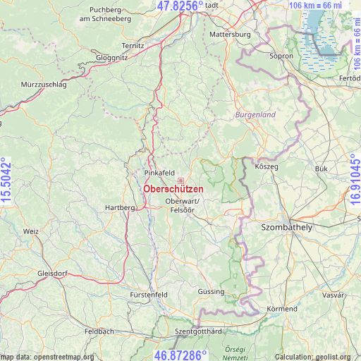
Oberschützen GPS coordinates[2]
47° 21' 4.968" North, 16° 12' 26.352" East
| Map corner | latitude | longitude |
|---|---|---|
| Upper-left | 47.8256°, | 15.5042° |
| Center: | 47.35138°, | 16.20732° |
| Lower-right: | 46.87286°, | 16.91045° |
| Map W x H: | 105.9×105.9 km | = 65.8×65.8mi |
| max Lat: | 48.98333° ⇑62.3% North |
| Oberschützen: | 47.35138° |
| min Lat: | ⇓37.7% South 46.48841° |
| min Long | Oberschützen | max Long |
| 9.57802° | 16.20732° | 17.1° |
| W 86.2%⇐ | ⇒13.8% E |
Elevation
Elevation of Oberschützen is 355 m = 1165 ft, and this is 150.5 m = 494 ft below average elevation for this country.
| Max E: |
2140 m = 7021 ft | 64.7% |
| Avg. | 505.5 m = 1658 ft | |
| Oberschützen | 355 m = 1165 ft | |
Min E: |
118 m = 387 ft | 35.3% |
See also: Austria elevation on elevation.city.
Geographical zone
Oberschützen is located in North temperate zone (between Tropic of Cancer and the Arctic Circle). Distance of this North polar circle is 2136.2 km =1327.4 mi to North.| Distance of | km | miles | from Oberschützen |
|---|---|---|---|
| North Pole | 4742.1 | 2946.6 | to North |
| Arctic Circle | 2136.2 | 1327.4 | to North |
| Tropic Cancer | 2659.1 | 1652.3 | to South |
| Equator | 5265 | 3271.5 | to South |


Nearby cities:
15 places around Oberschützen: (largest is in red/bold)
• Bad Tatzmannsdorf
2.8 km =1.7 mi,  141°
141°
• Bernstein
6.3 km =3.9 mi,  30°
30°
• Buchschachen
9 km =5.6 mi,  244°
244°
• Grafenschachen
10.7 km =6.6 mi,  279°
279°
• Jormannsdorf
0.7 km =0.4 mi,  102°
102°
• Loipersdorf im Burgenland
9.6 km =6 mi,  257°
257°
• Mariasdorf
2.4 km =1.5 mi,  48°
48°
• Oberwart
6.9 km =4.3 mi,  180°
180°
• Pinkafeld
7 km =4.3 mi, 283°
• Riedlingsdorf
5.6 km =3.5 mi,  268°
268°
• Rotenturm an der Pinka
11.7 km =7.3 mi,  164°
164°
• Stadtschlaining
6.9 km =4.3 mi,  123°
123°
• Unterkohlstätten
9 km =5.6 mi,  66°
66°
• Unterwart
11.4 km =7.1 mi,  170°
170°
• Wiesfleck
5.9 km =3.7 mi,  308°
308°
Sources, notices
• [Note1] Compared only with cities in Austria existing in our database
• [Src1] Map data: © OpenStreetMap contributors (CC-BY-SA)
• [Src2] Other city data from geonames.org with taken over terms of usage.
• [Src3] Geographical zone / Annual Mean Temperature by Robert A. Rohde @ Wikipedia
