Warth geodata
Warth (Lower Austria) is a seat of a third-order administrative division; located in Austria in Europe/Vienna (GMT+2) time zone. With population of 553 people, there are 2307 cities with bigger population in this country. Compared to other cities in Austria, 51.9% of cities are located further ↓South; 83.6% of cities are located further ←West and 52.1% of cities have lower elevation than Warth. Note1
Administrative division(s):
- Level 1: Lower Austria
- Level 2: Politischer Bezirk Neunkirchen
- Level 3: Warth


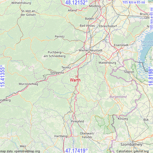
Warth GPS coordinates[2]
47° 39' 0" North, 16° 7' 0.012" East
| Map corner | latitude | longitude |
|---|---|---|
| Upper-left | 48.12152°, | 15.41355° |
| Center: | 47.65°, | 16.11667° |
| Lower-right: | 47.17419°, | 16.8198° |
| Map W x H: | 105.3×105.3 km | = 65.4×65.4mi |
| max Lat: | 48.98333° ⇑48.1% North |
| Warth: | 47.65° |
| min Lat: | ⇓51.9% South 46.48841° |
| min Long | Warth | max Long |
| 9.57802° | 16.11667° | 17.1° |
| W 83.6%⇐ | ⇒16.4% E |
Elevation
Elevation of Warth is 466 m = 1529 ft, and this is 39.5 m = 130 ft below average elevation for this country.
| Max E: |
2140 m = 7021 ft | 47.9% |
| Avg. | 505.5 m = 1658 ft | |
| Warth | 466 m = 1529 ft | |
Min E: |
118 m = 387 ft | 52.1% |
See also: Austria elevation on elevation.city.
Geographical zone
Warth is located in North temperate zone (between Tropic of Cancer and the Arctic Circle). Distance of this North polar circle is 2103 km =1306.7 mi to North.| Distance of | km | miles | from Warth |
|---|---|---|---|
| North Pole | 4708.9 | 2926 | to North |
| Arctic Circle | 2103 | 1306.7 | to North |
| Tropic Cancer | 2692.3 | 1672.9 | to South |
| Equator | 5298.2 | 3292.1 | to South |


Nearby cities:
15 places around Warth: (largest is in red/bold)
• Altendorf
7.5 km =4.7 mi,  270°
270°
• Bromberg
7.2 km =4.5 mi,  76°
76°
• Edlitz
6.1 km =3.8 mi,  162°
162°
• Feistritz am Wechsel
7.5 km =4.7 mi,  221°
221°
• Grimmenstein
3.8 km =2.4 mi,  168°
168°
• Königsberg
7.8 km =4.8 mi, 171°
• Lichtenegg
8.4 km =5.2 mi,  131°
131°
• Loipersbach
7.4 km =4.6 mi,  0°
0°
• Natschbach
7 km =4.3 mi,  348°
348°
• Neunkirchen
8.3 km =5.2 mi,  341°
341°
• Sankt Valentin-Landschach
8.4 km =5.2 mi,  296°
296°
• Scheiblingkirchen
1.9 km =1.2 mi,  45°
45°
• Seebenstein
5.9 km =3.7 mi,  21°
21°
• Thernberg
5 km =3.1 mi,  90°
90°
• Wartmannstetten
5.8 km =3.6 mi,  327°
327°
Sources, notices
• [Note1] Compared only with cities in Austria existing in our database
• [Src1] Map data: © OpenStreetMap contributors (CC-BY-SA)
• [Src2] Other city data from geonames.org with taken over terms of usage.
• [Src3] Geographical zone / Annual Mean Temperature by Robert A. Rohde @ Wikipedia
