Ladis geodata
Ladis (Tyrol) is a seat of a third-order administrative division; located in Austria in Europe/Vienna (GMT+2) time zone. With population of 531 people, there are 2394 cities with bigger population in this country. Compared to other cities in Austria, 80.6% of cities are located further ↑North; 95.3% of cities are located further →East and 97.9% of cities have lower elevation than Ladis. Note1


Ladis GPS coordinates[2]
47° 4' 28.524" North, 10° 38' 58.164" East
| Map corner | latitude | longitude |
|---|---|---|
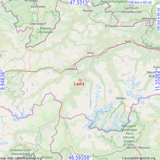
| Upper-left | 47.5513°, | 9.94636° |
| Center: | 47.07459°, | 10.64949° |
| Lower-right: | 46.59358°, | 11.35262° |
| Map W x H: | 106.5×106.5 km | = 66.2×66.2mi |
| max Lat: | 48.98333° ⇑80.6% North |
| Ladis: | 47.07459° |
| min Lat: | ⇓19.4% South 46.48841° |
| min Long | Ladis | max Long |
| 9.57802° | 10.64949° | 17.1° |
| W 4.7%⇐ | ⇒95.3% E |
Elevation
Elevation of Ladis is 1193 m = 3914 ft, and this is 687.5 m = 2256 ft above average elevation for this country.
| Max E: |
2140 m = 7021 ft | 2.1% |
| Ladis | 1193 m 3914 ft | |
| Avg. | 505.5 m = 1658 ft | |
Min E: |
118 m = 387 ft | 97.9% |
See also: Austria elevation on elevation.city.
Geographical zone
Ladis is located in North temperate zone (between Tropic of Cancer and the Arctic Circle). Distance of this North polar circle is 2167 km =1346.5 mi to North.| Distance of | km | miles | from Ladis |
|---|---|---|---|
| North Pole | 4772.9 | 2965.7 | to North |
| Arctic Circle | 2167 | 1346.5 | to North |
| Tropic Cancer | 2628.3 | 1633.1 | to South |
| Equator | 5234.2 | 3252.4 | to South |


Nearby cities:
15 places around Ladis: (largest is in red/bold)
• Fendels
3.1 km =1.9 mi,  137°
137°
• Fiss
3.1 km =1.9 mi,  231°
231°
• Fliess
5.3 km =3.3 mi,  332°
332°
• Jerzens
11.3 km =7 mi,  40°
40°
• Kaunertal
8.8 km =5.5 mi,  123°
123°
• Kauns
3.3 km =2.1 mi,  82°
82°
• Landeck
9.6 km =6 mi,  318°
318°
• Prutz
1.6 km =1 mi,  53°
53°
• Ried im Oberinntal
2.7 km =1.7 mi,  179°
179°
• Serfaus
5.2 km =3.2 mi,  222°
222°
• Stanz bei Landeck
10.9 km =6.8 mi, 318°
• Tobadill
11.7 km =7.3 mi,  298°
298°
• Tösens
7.1 km =4.4 mi,  207°
207°
• Wenns
12 km =7.5 mi,  31°
31°
• Zams
10.4 km =6.5 mi, 334°
Sources, notices
• [Note1] Compared only with cities in Austria existing in our database
• [Src1] Map data: © OpenStreetMap contributors (CC-BY-SA)
• [Src2] Other city data from geonames.org with taken over terms of usage.
• [Src3] Geographical zone / Annual Mean Temperature by Robert A. Rohde @ Wikipedia
