Landeck geodata
Landeck (Tyrol) is a seat of a third-order administrative division; located in Austria in Europe/Vienna (GMT+2) time zone. With population of 7,725 people, there are 117 cities with bigger population in this country. Compared to other cities in Austria, 76.6% of cities are located further ↑North; 95.6% of cities are located further →East and 84.4% of cities have lower elevation than Landeck. Note1


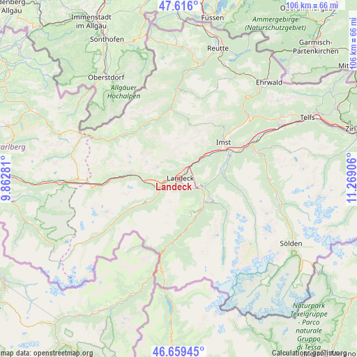
Landeck GPS coordinates[2]
47° 8' 23.568" North, 10° 33' 57.348" East
| Map corner | latitude | longitude |
|---|---|---|
| Upper-left | 47.616°, | 9.86281° |
| Center: | 47.13988°, | 10.56593° |
| Lower-right: | 46.65945°, | 11.26906° |
| Map W x H: | 106.4×106.4 km | = 66.1×66.1mi |
| max Lat: | 48.98333° ⇑76.6% North |
| Landeck: | 47.13988° |
| min Lat: | ⇓23.4% South 46.48841° |
| min Long | Landeck | max Long |
| 9.57802° | 10.56593° | 17.1° |
| W 4.4%⇐ | ⇒95.6% E |
Elevation
Elevation of Landeck is 789 m = 2589 ft, and this is 283.5 m = 930 ft above average elevation for this country.
| Max E: |
2140 m = 7021 ft | 15.6% |
| Landeck | 789 m 2589 ft | |
| Avg. | 505.5 m = 1658 ft | |
Min E: |
118 m = 387 ft | 84.4% |
See also: Austria elevation on elevation.city.
Geographical zone
Landeck is located in North temperate zone (between Tropic of Cancer and the Arctic Circle). Distance of this North polar circle is 2159.7 km =1342 mi to North.| Distance of | km | miles | from Landeck |
|---|---|---|---|
| North Pole | 4765.6 | 2961.2 | to North |
| Arctic Circle | 2159.7 | 1342 | to North |
| Tropic Cancer | 2635.5 | 1637.6 | to South |
| Equator | 5241.5 | 3256.9 | to South |


Nearby cities:
15 places around Landeck: (largest is in red/bold)
• Fiss
10 km =6.2 mi,  157°
157°
• Fliess
4.6 km =2.9 mi,  123°
123°
• Grins
3.9 km =2.4 mi,  270°
270°
• Kauns
11.8 km =7.3 mi,  125°
125°
• Ladis
9.6 km =6 mi,  138°
138°
• Mils bei Imst
11 km =6.8 mi,  48°
48°
• Pians
4.1 km =2.5 mi,  262°
262°
• Prutz
9.9 km =6.2 mi, 129°
• Schönwies
9.4 km =5.8 mi, 47°
• See
9.8 km =6.1 mi,  230°
230°
• Serfaus
11.4 km =7.1 mi,  165°
165°
• Stanz bei Landeck
1.3 km =0.8 mi,  312°
312°
• Strengen
8 km =5 mi, 258°
• Tobadill
4.3 km =2.7 mi,  247°
247°
• Zams
2.7 km =1.7 mi,  41°
41°
Sources, notices
• [Note1] Compared only with cities in Austria existing in our database
• [Src1] Map data: © OpenStreetMap contributors (CC-BY-SA)
• [Src2] Other city data from geonames.org with taken over terms of usage.
• [Src3] Geographical zone / Annual Mean Temperature by Robert A. Rohde @ Wikipedia
