Fiss geodata
Fiss (Tyrol) is a seat of a third-order administrative division; located in Austria in Europe/Vienna (GMT+2) time zone. With population of 1,009 people, there are 1278 cities with bigger population in this country. Compared to other cities in Austria, 81.7% of cities are located further ↑North; 95.4% of cities are located further →East and 99.6% of cities have lower elevation than Fiss. Note1


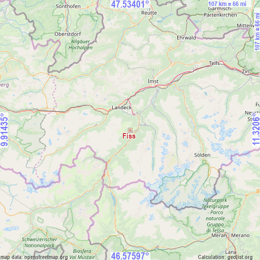
Fiss GPS coordinates[2]
47° 3' 25.704" North, 10° 37' 2.892" East
| Map corner | latitude | longitude |
|---|---|---|
| Upper-left | 47.53401°, | 9.91435° |
| Center: | 47.05714°, | 10.61747° |
| Lower-right: | 46.57597°, | 11.3206° |
| Map W x H: | 106.5×106.5 km | = 66.2×66.2mi |
| max Lat: | 48.98333° ⇑81.7% North |
| Fiss: | 47.05714° |
| min Lat: | ⇓18.3% South 46.48841° |
| min Long | Fiss | max Long |
| 9.57802° | 10.61747° | 17.1° |
| W 4.6%⇐ | ⇒95.4% E |
Elevation
Elevation of Fiss is 1464 m = 4803 ft, and this is 958.5 m = 3145 ft above average elevation for this country.
| Max E: |
2140 m = 7021 ft | 0.40000000000001% |
| Fiss | 1464 m 4803 ft | |
| Avg. | 505.5 m = 1658 ft | |
Min E: |
118 m = 387 ft | 99.6% |
See also: Austria elevation on elevation.city.
Geographical zone
Fiss is located in North temperate zone (between Tropic of Cancer and the Arctic Circle). Distance of this North polar circle is 2168.9 km =1347.7 mi to North.| Distance of | km | miles | from Fiss |
|---|---|---|---|
| North Pole | 4774.8 | 2966.9 | to North |
| Arctic Circle | 2168.9 | 1347.7 | to North |
| Tropic Cancer | 2626.3 | 1631.9 | to South |
| Equator | 5232.3 | 3251.2 | to South |


Nearby cities:
15 places around Fiss: (largest is in red/bold)
• Fendels
4.6 km =2.9 mi,  94°
94°
• Fliess
6.6 km =4.1 mi,  359°
359°
• Kaunertal
10.2 km =6.3 mi,  106°
106°
• Kauns
6.1 km =3.8 mi,  67°
67°
• Ladis
3.1 km =1.9 mi,  51°
51°
• Landeck
10 km =6.2 mi,  337°
337°
• Pfunds
11.3 km =7 mi,  206°
206°
• Pians
11.7 km =7.3 mi,  317°
317°
• Prutz
4.7 km =2.9 mi, 51°
• Ried im Oberinntal
2.6 km =1.6 mi, 107°
• Serfaus
2.2 km =1.4 mi, 209°
• Stanz bei Landeck
11.2 km =7 mi,  334°
334°
• Tobadill
10.9 km =6.8 mi,  313°
313°
• Tösens
4.4 km =2.7 mi,  190°
190°
• Zams
11.5 km =7.1 mi,  349°
349°
Sources, notices
• [Note1] Compared only with cities in Austria existing in our database
• [Src1] Map data: © OpenStreetMap contributors (CC-BY-SA)
• [Src2] Other city data from geonames.org with taken over terms of usage.
• [Src3] Geographical zone / Annual Mean Temperature by Robert A. Rohde @ Wikipedia
