Serfaus geodata
Serfaus (Tyrol) is a seat of a third-order administrative division; located in Austria in Europe/Vienna (GMT+1) time zone. With population of 1,134 people, there are 1119 cities with bigger population in this country. Compared to other cities in Austria, 82.4% of cities are located further ↑North; 95.5% of cities are located further →East and 99.5% of cities have lower elevation than Serfaus. Note1


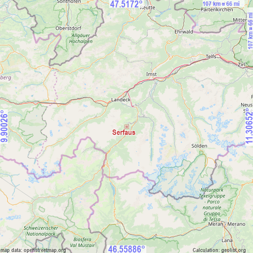
Serfaus GPS coordinates[2]
47° 2' 24.648" North, 10° 36' 12.204" East
| Map corner | latitude | longitude |
|---|---|---|
| Upper-left | 47.5172°, | 9.90026° |
| Center: | 47.04018°, | 10.60339° |
| Lower-right: | 46.55886°, | 11.30652° |
| Map W x H: | 106.6×106.6 km | = 66.2×66.2mi |
| max Lat: | 48.98333° ⇑82.4% North |
| Serfaus: | 47.04018° |
| min Lat: | ⇓17.6% South 46.48841° |
| min Long | Serfaus | max Long |
| 9.57802° | 10.60339° | 17.1° |
| W 4.5%⇐ | ⇒95.5% E |
Elevation
Elevation of Serfaus is 1449 m = 4754 ft, and this is 943.5 m = 3095 ft above average elevation for this country.
| Max E: |
2140 m = 7021 ft | 0.5% |
| Serfaus | 1449 m 4754 ft | |
| Avg. | 505.5 m = 1658 ft | |
Min E: |
118 m = 387 ft | 99.5% |
See also: Austria elevation on elevation.city.
Geographical zone
Serfaus is located in North temperate zone (between Tropic of Cancer and the Arctic Circle). Distance of this North polar circle is 2170.8 km =1348.9 mi to North.| Distance of | km | miles | from Serfaus |
|---|---|---|---|
| North Pole | 4776.7 | 2968.1 | to North |
| Arctic Circle | 2170.8 | 1348.9 | to North |
| Tropic Cancer | 2624.5 | 1630.8 | to South |
| Equator | 5230.4 | 3250 | to South |


Nearby cities:
15 places around Serfaus: (largest is in red/bold)
• Fendels
5.8 km =3.6 mi,  74°
74°
• Fiss
2.2 km =1.4 mi,  29°
29°
• Fliess
8.6 km =5.3 mi,  6°
6°
• Kaunertal
10.9 km =6.8 mi,  95°
95°
• Kauns
7.9 km =4.9 mi,  57°
57°
• Ladis
5.2 km =3.2 mi,  42°
42°
• Landeck
11.4 km =7.1 mi,  345°
345°
• Pfunds
9.1 km =5.7 mi,  206°
206°
• Pians
12.6 km =7.8 mi,  326°
326°
• Prutz
6.8 km =4.2 mi, 44°
• Ried im Oberinntal
3.7 km =2.3 mi, 72°
• See
11.4 km =7.1 mi,  294°
294°
• Stanz bei Landeck
12.5 km =7.8 mi,  342°
342°
• Tobadill
11.6 km =7.2 mi,  324°
324°
• Tösens
2.5 km =1.6 mi,  174°
174°
Sources, notices
• [Note1] Compared only with cities in Austria existing in our database
• [Src1] Map data: © OpenStreetMap contributors (CC-BY-SA)
• [Src2] Other city data from geonames.org with taken over terms of usage.
• [Src3] Geographical zone / Annual Mean Temperature by Robert A. Rohde @ Wikipedia
