Stoob geodata
Stoob (Burgenland) is a seat of a third-order administrative division; located in Austria in Europe/Vienna (GMT+2) time zone. With population of 1,386 people, there are 907 cities with bigger population in this country. Compared to other cities in Austria, 52.5% of cities are located further ↑North; 93.2% of cities are located further ←West and 82.5% of cities have higher elevation than Stoob. Note1
Administrative division(s):
- Level 1: Burgenland
- Level 2: Politischer Bezirk Oberpullendorf
- Level 3: Stoob


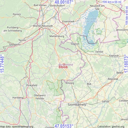
Stoob GPS coordinates[2]
47° 31' 42.42" North, 16° 28' 39.36" East
| Map corner | latitude | longitude |
|---|---|---|
| Upper-left | 48.00107°, | 15.77448° |
| Center: | 47.52845°, | 16.4776° |
| Lower-right: | 47.05153°, | 17.18073° |
| Map W x H: | 105.6×105.6 km | = 65.6×65.6mi |
| max Lat: | 48.98333° ⇑52.5% North |
| Stoob: | 47.52845° |
| min Lat: | ⇓47.5% South 46.48841° |
| min Long | Stoob | max Long |
| 9.57802° | 16.4776° | 17.1° |
| W 93.2%⇐ | ⇒6.8% E |
Elevation
Elevation of Stoob is 262 m = 860 ft, and this is 243.5 m = 799 ft below average elevation for this country.
| Max E: |
2140 m = 7021 ft | 82.5% |
| Avg. | 505.5 m = 1658 ft | |
| Stoob | 262 m = 860 ft | |
Min E: |
118 m = 387 ft | 17.5% |
See also: Austria elevation on elevation.city.
Geographical zone
Stoob is located in North temperate zone (between Tropic of Cancer and the Arctic Circle). Distance of this North polar circle is 2116.5 km =1315.1 mi to North.| Distance of | km | miles | from Stoob |
|---|---|---|---|
| North Pole | 4722.4 | 2934.4 | to North |
| Arctic Circle | 2116.5 | 1315.1 | to North |
| Tropic Cancer | 2678.7 | 1664.5 | to South |
| Equator | 5284.7 | 3283.8 | to South |


Nearby cities:
15 places around Stoob: (largest is in red/bold)
• Drassmarkt
6 km =3.7 mi,  257°
257°
• Dörfl im Burgenland
5 km =3.1 mi,  175°
175°
• Grosswarasdorf
5.8 km =3.6 mi,  78°
78°
• Horitschon
8.4 km =5.2 mi,  38°
38°
• Kaisersdorf
6.5 km =4 mi,  278°
278°
• Lackenbach
7 km =4.3 mi,  352°
352°
• Lackendorf
7.1 km =4.4 mi,  16°
16°
• Markt Sankt Martin
5.4 km =3.4 mi,  313°
313°
• Mitterpullendorf
5.1 km =3.2 mi,  140°
140°
• Neutal
3 km =1.9 mi, 308°
• Oberpullendorf
3.4 km =2.1 mi, 143°
• Raiding
5.7 km =3.5 mi, 43°
• Steinberg an der Rabnitz
6.1 km =3.8 mi,  172°
172°
• Unterfrauenhaid
5 km =3.1 mi, 18°
• Weppersdorf
6.8 km =4.2 mi,  326°
326°
Sources, notices
• [Note1] Compared only with cities in Austria existing in our database
• [Src1] Map data: © OpenStreetMap contributors (CC-BY-SA)
• [Src2] Other city data from geonames.org with taken over terms of usage.
• [Src3] Geographical zone / Annual Mean Temperature by Robert A. Rohde @ Wikipedia
