Lackendorf geodata
Lackendorf (Burgenland) is a seat of a third-order administrative division; located in Austria in Europe/Vienna (GMT+2) time zone. With population of 604 people, there are 2126 cities with bigger population in this country. Compared to other cities in Austria, 50.2% of cities are located further ↓South; 94% of cities are located further ←West and 80.4% of cities have higher elevation than Lackendorf. Note1
Administrative division(s):
- Level 1: Burgenland
- Level 2: Politischer Bezirk Oberpullendorf
- Level 3: Lackendorf


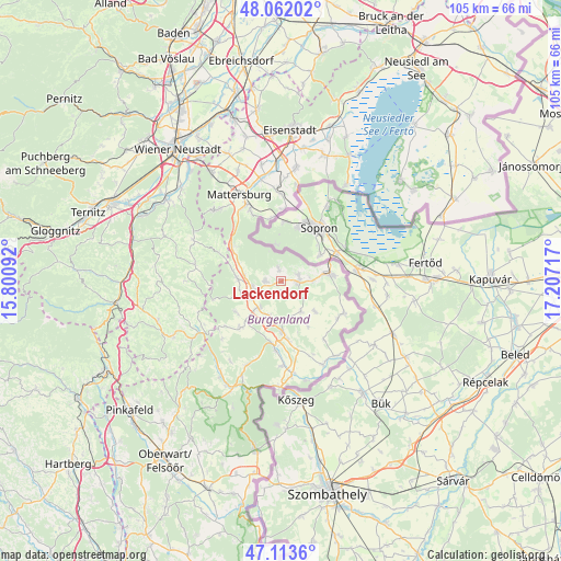
Lackendorf GPS coordinates[2]
47° 35' 23.856" North, 16° 30' 14.544" East
| Map corner | latitude | longitude |
|---|---|---|
| Upper-left | 48.06202°, | 15.80092° |
| Center: | 47.58996°, | 16.50404° |
| Lower-right: | 47.1136°, | 17.20717° |
| Map W x H: | 105.5×105.5 km | = 65.6×65.6mi |
| max Lat: | 48.98333° ⇑49.8% North |
| Lackendorf: | 47.58996° |
| min Lat: | ⇓50.2% South 46.48841° |
| min Long | Lackendorf | max Long |
| 9.57802° | 16.50404° | 17.1° |
| W 94%⇐ | ⇒6% E |
Elevation
Elevation of Lackendorf is 273 m = 896 ft, and this is 232.5 m = 763 ft below average elevation for this country.
| Max E: |
2140 m = 7021 ft | 80.4% |
| Avg. | 505.5 m = 1658 ft | |
| Lackendorf | 273 m = 896 ft | |
Min E: |
118 m = 387 ft | 19.6% |
See also: Austria elevation on elevation.city.
Geographical zone
Lackendorf is located in North temperate zone (between Tropic of Cancer and the Arctic Circle). Distance of this North polar circle is 2109.7 km =1310.9 mi to North.| Distance of | km | miles | from Lackendorf |
|---|---|---|---|
| North Pole | 4715.6 | 2930.1 | to North |
| Arctic Circle | 2109.7 | 1310.9 | to North |
| Tropic Cancer | 2685.6 | 1668.8 | to South |
| Equator | 5291.5 | 3288 | to South |


Nearby cities:
15 places around Lackendorf: (largest is in red/bold)
• Deutschkreutz
9.8 km =6.1 mi,  83°
83°
• Grosswarasdorf
6.7 km =4.2 mi,  146°
146°
• Horitschon
3.2 km =2 mi,  95°
95°
• Kobersdorf
8.4 km =5.2 mi,  274°
274°
• Lackenbach
2.9 km =1.8 mi, 271°
• Markt Sankt Martin
6.7 km =4.2 mi,  242°
242°
• Neckenmarkt
3.4 km =2.1 mi,  71°
71°
• Neutal
6.6 km =4.1 mi,  221°
221°
• Oberpullendorf
9.6 km =6 mi,  179°
179°
• Raiding
3.3 km =2.1 mi,  143°
143°
• Ritzing
2.7 km =1.7 mi,  345°
345°
• Stoob
7.1 km =4.4 mi,  196°
196°
• Tschurndorf
7.6 km =4.7 mi,  284°
284°
• Unterfrauenhaid
2.1 km =1.3 mi,  190°
190°
• Weppersdorf
5.9 km =3.7 mi,  258°
258°
Sources, notices
• [Note1] Compared only with cities in Austria existing in our database
• [Src1] Map data: © OpenStreetMap contributors (CC-BY-SA)
• [Src2] Other city data from geonames.org with taken over terms of usage.
• [Src3] Geographical zone / Annual Mean Temperature by Robert A. Rohde @ Wikipedia
