Oberpullendorf geodata
Oberpullendorf (Burgenland) is a seat of a second-order administrative division; located in Austria in Europe/Vienna (GMT+2) time zone. With population of 2,019 people, there are 608 cities with bigger population in this country. Compared to other cities in Austria, 53.5% of cities are located further ↑North; 94% of cities are located further ←West and 85.1% of cities have higher elevation than Oberpullendorf. Note1
Administrative division(s):
- Level 1: Burgenland
- Level 2: Politischer Bezirk Oberpullendorf
- Level 3: Oberpullendorf


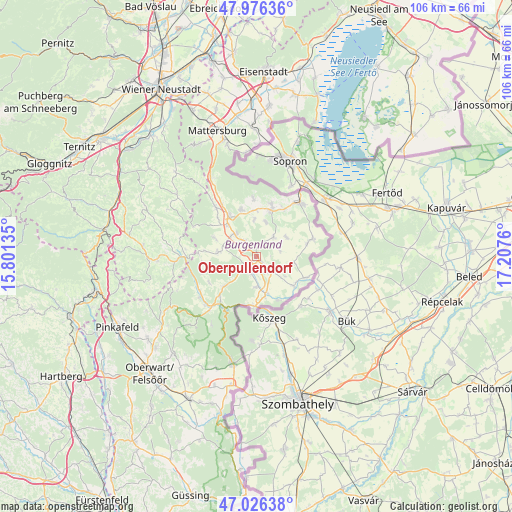
Oberpullendorf GPS coordinates[2]
47° 30' 12.672" North, 16° 30' 16.092" East
| Map corner | latitude | longitude |
|---|---|---|
| Upper-left | 47.97636°, | 15.80135° |
| Center: | 47.50352°, | 16.50447° |
| Lower-right: | 47.02638°, | 17.2076° |
| Map W x H: | 105.6×105.6 km | = 65.6×65.6mi |
| max Lat: | 48.98333° ⇑53.5% North |
| Oberpullendorf: | 47.50352° |
| min Lat: | ⇓46.5% South 46.48841° |
| min Long | Oberpullendorf | max Long |
| 9.57802° | 16.50447° | 17.1° |
| W 94%⇐ | ⇒6% E |
Elevation
Elevation of Oberpullendorf is 246 m = 807 ft, and this is 259.5 m = 851 ft below average elevation for this country.
| Max E: |
2140 m = 7021 ft | 85.1% |
| Avg. | 505.5 m = 1658 ft | |
| Oberpullendorf | 246 m = 807 ft | |
Min E: |
118 m = 387 ft | 14.9% |
See also: Austria elevation on elevation.city.
Geographical zone
Oberpullendorf is located in North temperate zone (between Tropic of Cancer and the Arctic Circle). Distance of this North polar circle is 2119.3 km =1316.9 mi to North.| Distance of | km | miles | from Oberpullendorf |
|---|---|---|---|
| North Pole | 4725.2 | 2936.1 | to North |
| Arctic Circle | 2119.3 | 1316.9 | to North |
| Tropic Cancer | 2676 | 1662.8 | to South |
| Equator | 5281.9 | 3282 | to South |


Nearby cities:
15 places around Oberpullendorf: (largest is in red/bold)
• Drassmarkt
8 km =5 mi,  280°
280°
• Dörfl im Burgenland
2.7 km =1.7 mi,  215°
215°
• Grosswarasdorf
5.4 km =3.4 mi,  42°
42°
• Kaisersdorf
9.2 km =5.7 mi,  294°
294°
• Lackendorf
9.6 km =6 mi,  359°
359°
• Mannersdorf an der Rabnitz
8.5 km =5.3 mi,  168°
168°
• Markt Sankt Martin
8.8 km =5.5 mi,  317°
317°
• Mitterpullendorf
1.7 km =1.1 mi,  132°
132°
• Neutal
6.4 km =4 mi, 316°
• Oberloisdorf
6.2 km =3.9 mi,  177°
177°
• Piringsdorf
9.1 km =5.7 mi,  227°
227°
• Raiding
7.2 km =4.5 mi,  15°
15°
• Steinberg an der Rabnitz
3.5 km =2.2 mi,  201°
201°
• Stoob
3.4 km =2.1 mi, 323°
• Unterfrauenhaid
7.5 km =4.7 mi, 356°
Sources, notices
• [Note1] Compared only with cities in Austria existing in our database
• [Src1] Map data: © OpenStreetMap contributors (CC-BY-SA)
• [Src2] Other city data from geonames.org with taken over terms of usage.
• [Src3] Geographical zone / Annual Mean Temperature by Robert A. Rohde @ Wikipedia
