Schweizersberg geodata
Schweizersberg (Upper Austria) is a populated place; located in Austria in Europe/Vienna (GMT+2) time zone. With population of 525 people, there are 2408 cities with bigger population in this country. Compared to other cities in Austria, 54.1% of cities are located further ↓South; 58.3% of cities are located further →East and 84.1% of cities have lower elevation than Schweizersberg. Note1
Administrative division(s):
- Level 1: Upper Austria
- Level 2: Politischer Bezirk Kirchdorf an der Krems
- Level 3: Rossleithen


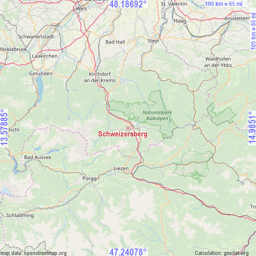
Schweizersberg GPS coordinates[2]
47° 42' 57.6" North, 14° 16' 55.092" East
| Map corner | latitude | longitude |
|---|---|---|
| Upper-left | 48.18692°, | 13.57885° |
| Center: | 47.716°, | 14.28197° |
| Lower-right: | 47.24078°, | 14.9851° |
| Map W x H: | 105.2×105.2 km | = 65.4×65.4mi |
| max Lat: | 48.98333° ⇑45.9% North |
| Schweizersberg: | 47.716° |
| min Lat: | ⇓54.1% South 46.48841° |
| min Long | Schweizersberg | max Long |
| 9.57802° | 14.28197° | 17.1° |
| W 41.7%⇐ | ⇒58.3% E |
Elevation
Elevation of Schweizersberg is 784 m = 2572 ft, and this is 278.5 m = 914 ft above average elevation for this country.
| Max E: |
2140 m = 7021 ft | 15.9% |
| Schweizersberg | 784 m 2572 ft | |
| Avg. | 505.5 m = 1658 ft | |
Min E: |
118 m = 387 ft | 84.1% |
See also: Austria elevation on elevation.city.
Geographical zone
Schweizersberg is located in North temperate zone (between Tropic of Cancer and the Arctic Circle). Distance of this North polar circle is 2095.7 km =1302.2 mi to North.| Distance of | km | miles | from Schweizersberg |
|---|---|---|---|
| North Pole | 4701.5 | 2921.4 | to North |
| Arctic Circle | 2095.7 | 1302.2 | to North |
| Tropic Cancer | 2699.6 | 1677.5 | to South |
| Equator | 5305.5 | 3296.7 | to South |


Nearby cities:
15 places around Schweizersberg: (largest is in red/bold)
• Admont
20.6 km =12.8 mi,  139°
139°
• Ardning
15.2 km =9.4 mi,  156°
156°
• Edlbach
4.7 km =2.9 mi,  91°
91°
• Hall bei Admont
19.8 km =12.3 mi, 136°
• Klausner
16.4 km =10.2 mi, 161°
• Lassing
20.3 km =12.6 mi,  185°
185°
• Leonstein
20.4 km =12.7 mi,  349°
349°
• Liezen
17 km =10.6 mi, 192°
• Molln
19.1 km =11.9 mi, 354°
• Ramsau
14 km =8.7 mi, 353°
• Selzthal
18.6 km =11.6 mi,  173°
173°
• Spital am Pyhrn
7.2 km =4.5 mi, 142°
• Steyrling
15.1 km =9.4 mi,  311°
311°
• Weißenbach bei Liezen
17.3 km =10.7 mi,  196°
196°
• Windischgarsten
3.5 km =2.2 mi,  78°
78°
Sources, notices
• [Note1] Compared only with cities in Austria existing in our database
• [Src1] Map data: © OpenStreetMap contributors (CC-BY-SA)
• [Src2] Other city data from geonames.org with taken over terms of usage.
• [Src3] Geographical zone / Annual Mean Temperature by Robert A. Rohde @ Wikipedia
