Ramsau geodata
Ramsau (Upper Austria) is a populated place; located in Austria in Europe/Vienna (GMT+2) time zone. With population of 733 people, there are 1767 cities with bigger population in this country. Compared to other cities in Austria, 58.5% of cities are located further ↓South; 58.9% of cities are located further →East and 83.5% of cities have lower elevation than Ramsau. Note1
Administrative division(s):
- Level 1: Upper Austria
- Level 2: Politischer Bezirk Kirchdorf an der Krems
- Level 3: Molln


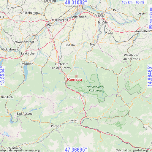
Ramsau GPS coordinates[2]
47° 50' 27.708" North, 14° 15' 41.472" East
| Map corner | latitude | longitude |
|---|---|---|
| Upper-left | 48.31082°, | 13.5584° |
| Center: | 47.84103°, | 14.26152° |
| Lower-right: | 47.36695°, | 14.96465° |
| Map W x H: | 104.9×104.9 km | = 65.2×65.2mi |
| max Lat: | 48.98333° ⇑41.5% North |
| Ramsau: | 47.84103° |
| min Lat: | ⇓58.5% South 46.48841° |
| min Long | Ramsau | max Long |
| 9.57802° | 14.26152° | 17.1° |
| W 41.1%⇐ | ⇒58.9% E |
Elevation
Elevation of Ramsau is 776 m = 2546 ft, and this is 270.5 m = 887 ft above average elevation for this country.
| Max E: |
2140 m = 7021 ft | 16.5% |
| Ramsau | 776 m 2546 ft | |
| Avg. | 505.5 m = 1658 ft | |
Min E: |
118 m = 387 ft | 83.5% |
See also: Austria elevation on elevation.city.
Geographical zone
Ramsau is located in North temperate zone (between Tropic of Cancer and the Arctic Circle). Distance of this North polar circle is 2081.8 km =1293.6 mi to North.| Distance of | km | miles | from Ramsau |
|---|---|---|---|
| North Pole | 4687.6 | 2912.7 | to North |
| Arctic Circle | 2081.8 | 1293.6 | to North |
| Tropic Cancer | 2713.5 | 1686.1 | to South |
| Equator | 5319.4 | 3305.3 | to South |


Nearby cities:
15 places around Ramsau: (largest is in red/bold)
• Grünburg
14.6 km =9.1 mi,  0°
0°
• Hausmanning
13 km =8.1 mi,  307°
307°
• Kirchdorf an der Krems
12.6 km =7.8 mi,  304°
304°
• Leonstein
6.6 km =4.1 mi,  339°
339°
• Micheldorf in Oberösterreich
10.4 km =6.5 mi,  293°
293°
• Molln
5.1 km =3.2 mi,  357°
357°
• Obergrünburg
12.3 km =7.6 mi, 357°
• Reichraming
14.8 km =9.2 mi,  71°
71°
• Schweizersberg
14 km =8.7 mi,  173°
173°
• Steinbach an der Steyr
14.4 km =8.9 mi, 2°
• Steyrling
10.5 km =6.5 mi,  248°
248°
• Ternberg
13.7 km =8.5 mi,  32°
32°
• Untergrünburg
14.5 km =9 mi, 0°
• Windischgarsten
14.1 km =8.8 mi,  159°
159°
• Zehetner
13.2 km =8.2 mi, 4°
Sources, notices
• [Note1] Compared only with cities in Austria existing in our database
• [Src1] Map data: © OpenStreetMap contributors (CC-BY-SA)
• [Src2] Other city data from geonames.org with taken over terms of usage.
• [Src3] Geographical zone / Annual Mean Temperature by Robert A. Rohde @ Wikipedia
