Molln geodata
Molln (Upper Austria) is a populated place; located in Austria in Europe/Vienna (GMT+2) time zone. With population of 2,434 people, there are 489 cities with bigger population in this country. Compared to other cities in Austria, 60.5% of cities are located further ↓South; 59.1% of cities are located further →East and 54.9% of cities have higher elevation than Molln. Note1
Administrative division(s):
- Level 1: Upper Austria
- Level 2: Politischer Bezirk Kirchdorf an der Krems
- Level 3: Molln


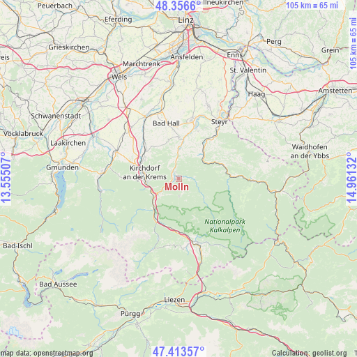
Molln GPS coordinates[2]
47° 53' 14.028" North, 14° 15' 29.484" East
| Map corner | latitude | longitude |
|---|---|---|
| Upper-left | 48.3566°, | 13.55507° |
| Center: | 47.88723°, | 14.25819° |
| Lower-right: | 47.41357°, | 14.96132° |
| Map W x H: | 104.9×104.9 km | = 65.2×65.2mi |
| max Lat: | 48.98333° ⇑39.5% North |
| Molln: | 47.88723° |
| min Lat: | ⇓60.5% South 46.48841° |
| min Long | Molln | max Long |
| 9.57802° | 14.25819° | 17.1° |
| W 40.9%⇐ | ⇒59.1% E |
Elevation
Elevation of Molln is 421 m = 1381 ft, and this is 84.5 m = 277 ft below average elevation for this country.
| Max E: |
2140 m = 7021 ft | 54.9% |
| Avg. | 505.5 m = 1658 ft | |
| Molln | 421 m = 1381 ft | |
Min E: |
118 m = 387 ft | 45.1% |
See also: Austria elevation on elevation.city.
Geographical zone
Molln is located in North temperate zone (between Tropic of Cancer and the Arctic Circle). Distance of this North polar circle is 2076.6 km =1290.3 mi to North.| Distance of | km | miles | from Molln |
|---|---|---|---|
| North Pole | 4682.5 | 2909.6 | to North |
| Arctic Circle | 2076.6 | 1290.3 | to North |
| Tropic Cancer | 2718.6 | 1689.3 | to South |
| Equator | 5324.6 | 3308.6 | to South |


Nearby cities:
15 places around Molln: (largest is in red/bold)
• Adlwang
12.1 km =7.5 mi,  345°
345°
• Grünburg
9.5 km =5.9 mi,  2°
2°
• Hausmanning
10.4 km =6.5 mi,  285°
285°
• Kirchdorf an der Krems
10.3 km =6.4 mi,  281°
281°
• Leonstein
2.3 km =1.4 mi,  297°
297°
• Micheldorf in Oberösterreich
9.4 km =5.8 mi,  263°
263°
• Nussbach
11.8 km =7.3 mi,  323°
323°
• Obergrünburg
7.1 km =4.4 mi,  358°
358°
• Ramsau
5.1 km =3.2 mi,  177°
177°
• Schlierbach
11.6 km =7.2 mi, 297°
• Steinbach an der Steyr
9.3 km =5.8 mi,  5°
5°
• Ternberg
9.9 km =6.2 mi,  49°
49°
• Untergrünburg
9.4 km =5.8 mi, 2°
• Waldneukirchen
12.4 km =7.7 mi, 0°
• Zehetner
8.1 km =5 mi, 9°
Sources, notices
• [Note1] Compared only with cities in Austria existing in our database
• [Src1] Map data: © OpenStreetMap contributors (CC-BY-SA)
• [Src2] Other city data from geonames.org with taken over terms of usage.
• [Src3] Geographical zone / Annual Mean Temperature by Robert A. Rohde @ Wikipedia
