Paldau geodata
Paldau (Styria) is a seat of a third-order administrative division; located in Austria in Europe/Vienna (GMT+2) time zone. With population of 897 people, there are 1437 cities with bigger population in this country. Compared to other cities in Austria, 86.6% of cities are located further ↑North; 74.6% of cities are located further ←West and 72.6% of cities have higher elevation than Paldau. Note1
Administrative division(s):
- Level 1: Styria
- Level 2: Politischer Bezirk Südoststeiermark
- Level 3: Paldau


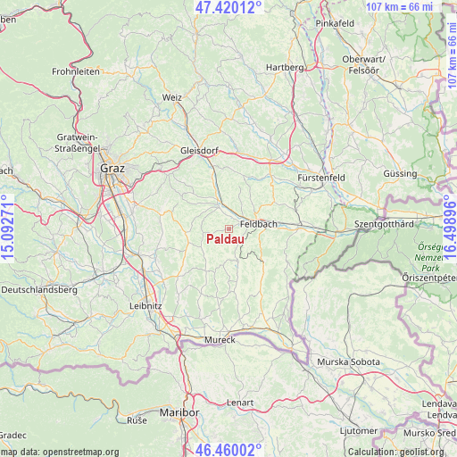
Paldau GPS coordinates[2]
46° 56' 31.992" North, 15° 47' 44.988" East
| Map corner | latitude | longitude |
|---|---|---|
| Upper-left | 47.42012°, | 15.09271° |
| Center: | 46.94222°, | 15.79583° |
| Lower-right: | 46.46002°, | 16.49896° |
| Map W x H: | 106.8×106.8 km | = 66.4×66.4mi |
| max Lat: | 48.98333° ⇑86.6% North |
| Paldau: | 46.94222° |
| min Lat: | ⇓13.4% South 46.48841° |
| min Long | Paldau | max Long |
| 9.57802° | 15.79583° | 17.1° |
| W 74.6%⇐ | ⇒25.4% E |
Elevation
Elevation of Paldau is 316 m = 1037 ft, and this is 189.5 m = 622 ft below average elevation for this country.
| Max E: |
2140 m = 7021 ft | 72.6% |
| Avg. | 505.5 m = 1658 ft | |
| Paldau | 316 m = 1037 ft | |
Min E: |
118 m = 387 ft | 27.4% |
See also: Austria elevation on elevation.city.
Geographical zone
Paldau is located in North temperate zone (between Tropic of Cancer and the Arctic Circle). Distance of this North polar circle is 2181.7 km =1355.6 mi to North.| Distance of | km | miles | from Paldau |
|---|---|---|---|
| North Pole | 4787.6 | 2974.9 | to North |
| Arctic Circle | 2181.7 | 1355.6 | to North |
| Tropic Cancer | 2613.6 | 1624 | to South |
| Equator | 5219.5 | 3243.2 | to South |


Nearby cities:
15 places around Paldau: (largest is in red/bold)
• Baumgarten bei Gnas
3.6 km =2.2 mi,  217°
217°
• Edelsbach bei Feldbach
6.1 km =3.8 mi,  30°
30°
• Feldbach
7.1 km =4.4 mi,  80°
80°
• Fladnitz im Raabtal
5.6 km =3.5 mi,  351°
351°
• Gniebing
5.1 km =3.2 mi,  63°
63°
• Kirchberg an der Raab
5.3 km =3.3 mi,  335°
335°
• Kohlberg
4.8 km =3 mi,  191°
191°
• Maierdorf
6.9 km =4.3 mi,  143°
143°
• Mitterfladnitz
7.6 km =4.7 mi,  3°
3°
• Oberdorf am Hochegg
6.9 km =4.3 mi,  305°
305°
• Oberstorcha
2.7 km =1.7 mi,  6°
6°
• Oedt bei Feldbach
5.3 km =3.3 mi,  97°
97°
• Perlsdorf
3.5 km =2.2 mi,  156°
156°
• Unterweissenbach
4.2 km =2.6 mi, 78°
• Wörth bei Kirchberg an der Raab
3.5 km =2.2 mi,  320°
320°
Sources, notices
• [Note1] Compared only with cities in Austria existing in our database
• [Src1] Map data: © OpenStreetMap contributors (CC-BY-SA)
• [Src2] Other city data from geonames.org with taken over terms of usage.
• [Src3] Geographical zone / Annual Mean Temperature by Robert A. Rohde @ Wikipedia
