Kohlberg geodata
Kohlberg (Styria) is a seat of a third-order administrative division; located in Austria in Europe/Vienna (GMT+1) time zone. With population of 298 people, there are 2746 cities with bigger population in this country. Compared to other cities in Austria, 87.9% of cities are located further ↑North; 74.2% of cities are located further ←West and 63.4% of cities have higher elevation than Kohlberg. Note1
Administrative division(s):
- Level 1: Styria
- Level 2: Politischer Bezirk Südoststeiermark
- Level 3: Gnas


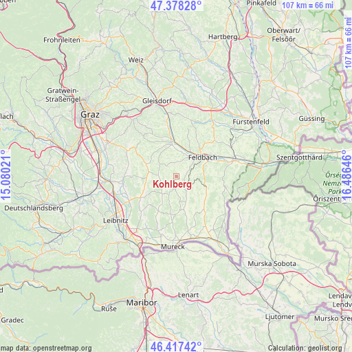
Kohlberg GPS coordinates[2]
46° 54' 0" North, 15° 46' 59.988" East
| Map corner | latitude | longitude |
|---|---|---|
| Upper-left | 47.37828°, | 15.08021° |
| Center: | 46.9°, | 15.78333° |
| Lower-right: | 46.41742°, | 16.48646° |
| Map W x H: | 106.8×106.8 km | = 66.4×66.4mi |
| max Lat: | 48.98333° ⇑87.9% North |
| Kohlberg: | 46.9° |
| min Lat: | ⇓12.1% South 46.48841° |
| min Long | Kohlberg | max Long |
| 9.57802° | 15.78333° | 17.1° |
| W 74.2%⇐ | ⇒25.8% E |
Elevation
Elevation of Kohlberg is 361 m = 1184 ft, and this is 144.5 m = 474 ft below average elevation for this country.
| Max E: |
2140 m = 7021 ft | 63.4% |
| Avg. | 505.5 m = 1658 ft | |
| Kohlberg | 361 m = 1184 ft | |
Min E: |
118 m = 387 ft | 36.6% |
See also: Austria elevation on elevation.city.
Geographical zone
Kohlberg is located in North temperate zone (between Tropic of Cancer and the Arctic Circle). Distance of this North polar circle is 2186.4 km =1358.6 mi to North.| Distance of | km | miles | from Kohlberg |
|---|---|---|---|
| North Pole | 4792.3 | 2977.8 | to North |
| Arctic Circle | 2186.4 | 1358.6 | to North |
| Tropic Cancer | 2608.9 | 1621.1 | to South |
| Equator | 5214.8 | 3240.3 | to South |


Nearby cities:
15 places around Kohlberg: (largest is in red/bold)
• Baumgarten bei Gnas
2.2 km =1.4 mi,  325°
325°
• Burgfried
4.5 km =2.8 mi,  121°
121°
• Gnas
4.4 km =2.7 mi,  133°
133°
• Grabersdorf
7.1 km =4.4 mi,  153°
153°
• Jagerberg
6.2 km =3.9 mi,  213°
213°
• Maierdorf
5.1 km =3.2 mi,  99°
99°
• Oberstorcha
7.5 km =4.7 mi,  9°
9°
• Oedt bei Feldbach
7.4 km =4.6 mi,  56°
56°
• Paldau
4.8 km =3 mi, 11°
• Perlsdorf
2.8 km =1.7 mi, 57°
• Poppendorf
7.4 km =4.6 mi, 131°
• Raning
6.1 km =3.8 mi,  155°
155°
• Sankt Stefan im Rosental
5.6 km =3.5 mi,  274°
274°
• Unterauersbach
4 km =2.5 mi,  194°
194°
• Unterweissenbach
7.5 km =4.7 mi,  42°
42°
Sources, notices
• [Note1] Compared only with cities in Austria existing in our database
• [Src1] Map data: © OpenStreetMap contributors (CC-BY-SA)
• [Src2] Other city data from geonames.org with taken over terms of usage.
• [Src3] Geographical zone / Annual Mean Temperature by Robert A. Rohde @ Wikipedia
