Walserfeld geodata
Walserfeld (Salzburg) is a populated place; located in Austria in Europe/Vienna (GMT+2) time zone. With population of 1,050 people, there are 1216 cities with bigger population in this country. Compared to other cities in Austria, 56.8% of cities are located further ↓South; 83.4% of cities are located further →East and 52.1% of cities have higher elevation than Walserfeld. Note1
Administrative division(s):
- Level 1: Salzburg
- Level 2: Politischer Bezirk Salzburg-Umgebung
- Level 3: Wals-Siezenheim


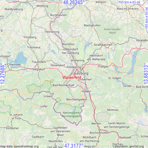
Walserfeld GPS coordinates[2]
47° 47' 31.992" North, 12° 58' 48" East
| Map corner | latitude | longitude |
|---|---|---|
| Upper-left | 48.26245°, | 12.27688° |
| Center: | 47.79222°, | 12.98° |
| Lower-right: | 47.3177°, | 13.68313° |
| Map W x H: | 105×105 km | = 65.2×65.2mi |
| max Lat: | 48.98333° ⇑43.2% North |
| Walserfeld: | 47.79222° |
| min Lat: | ⇓56.8% South 46.48841° |
| min Long | Walserfeld | max Long |
| 9.57802° | 12.98° | 17.1° |
| W 16.6%⇐ | ⇒83.4% E |
Elevation
Elevation of Walserfeld is 438 m = 1437 ft, and this is 67.5 m = 221 ft below average elevation for this country.
| Max E: |
2140 m = 7021 ft | 52.1% |
| Avg. | 505.5 m = 1658 ft | |
| Walserfeld | 438 m = 1437 ft | |
Min E: |
118 m = 387 ft | 47.9% |
See also: Austria elevation on elevation.city.
Geographical zone
Walserfeld is located in North temperate zone (between Tropic of Cancer and the Arctic Circle). Distance of this North polar circle is 2087.2 km =1296.9 mi to North.| Distance of | km | miles | from Walserfeld |
|---|---|---|---|
| North Pole | 4693.1 | 2916.2 | to North |
| Arctic Circle | 2087.2 | 1296.9 | to North |
| Tropic Cancer | 2708.1 | 1682.7 | to South |
| Equator | 5314 | 3302 | to South |


Nearby cities:
15 places around Walserfeld: (largest is in red/bold)
• Anif
8 km =5 mi,  125°
125°
• Bergheim
6.1 km =3.8 mi,  41°
41°
• Elsbethen
8.1 km =5 mi,  112°
112°
• Glanegg
4.9 km =3 mi,  162°
162°
• Glasenbach
8.2 km =5.1 mi, 110°
• Gois
3 km =1.9 mi,  199°
199°
• Grödig
7.4 km =4.6 mi,  144°
144°
• Himmelreich
0.9 km =0.6 mi,  16°
16°
• Käferheim
2.4 km =1.5 mi,  246°
246°
• Lengfelden
8.3 km =5.2 mi, 39°
• Salzburg
4.8 km =3 mi,  80°
80°
• Siezenheim
2.7 km =1.7 mi, 16°
• Viehhausen
1 km =0.6 mi,  165°
165°
• Wals
1.4 km =0.9 mi,  225°
225°
• Walserberg
2.6 km =1.6 mi,  219°
219°
Sources, notices
• [Note1] Compared only with cities in Austria existing in our database
• [Src1] Map data: © OpenStreetMap contributors (CC-BY-SA)
• [Src2] Other city data from geonames.org with taken over terms of usage.
• [Src3] Geographical zone / Annual Mean Temperature by Robert A. Rohde @ Wikipedia
