Stiwoll geodata
Stiwoll (Styria) is a seat of a third-order administrative division; located in Austria in Europe/Vienna (GMT+1) time zone. With population of 722 people, there are 1798 cities with bigger population in this country. Compared to other cities in Austria, 79.3% of cities are located further ↑North; 57.8% of cities are located further ←West and 57.5% of cities have lower elevation than Stiwoll. Note1
Administrative division(s):
- Level 1: Styria
- Level 2: Politischer Bezirk Graz-Umgebung
- Level 3: Stiwoll


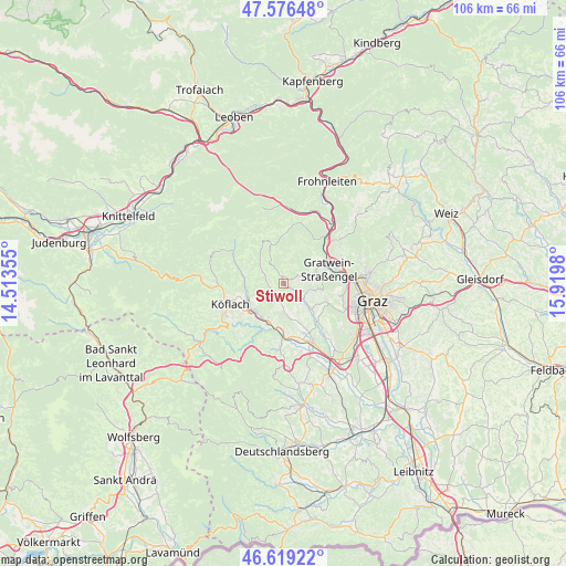
Stiwoll GPS coordinates[2]
47° 6' 0" North, 15° 13' 0.012" East
| Map corner | latitude | longitude |
|---|---|---|
| Upper-left | 47.57648°, | 14.51355° |
| Center: | 47.1°, | 15.21667° |
| Lower-right: | 46.61922°, | 15.9198° |
| Map W x H: | 106.4×106.4 km | = 66.1×66.1mi |
| max Lat: | 48.98333° ⇑79.3% North |
| Stiwoll: | 47.1° |
| min Lat: | ⇓20.7% South 46.48841° |
| min Long | Stiwoll | max Long |
| 9.57802° | 15.21667° | 17.1° |
| W 57.8%⇐ | ⇒42.2% E |
Elevation
Elevation of Stiwoll is 501 m = 1644 ft, and this is 4.5 m = 15 ft below average elevation for this country.
| Max E: |
2140 m = 7021 ft | 42.5% |
| Avg. | 505.5 m = 1658 ft | |
| Stiwoll | 501 m = 1644 ft | |
Min E: |
118 m = 387 ft | 57.5% |
See also: Austria elevation on elevation.city.
Geographical zone
Stiwoll is located in North temperate zone (between Tropic of Cancer and the Arctic Circle). Distance of this North polar circle is 2164.1 km =1344.7 mi to North.| Distance of | km | miles | from Stiwoll |
|---|---|---|---|
| North Pole | 4770 | 2963.9 | to North |
| Arctic Circle | 2164.1 | 1344.7 | to North |
| Tropic Cancer | 2631.1 | 1634.9 | to South |
| Equator | 5237 | 3254.1 | to South |


Nearby cities:
15 places around Stiwoll: (largest is in red/bold)
• Bärnbach
7.4 km =4.6 mi,  244°
244°
• Eisbach
4.2 km =2.6 mi,  63°
63°
• Gratwein
7.8 km =4.8 mi,  76°
76°
• Hochtregist
6.3 km =3.9 mi,  270°
270°
• Jaritzberg
3.1 km =1.9 mi,  126°
126°
• Piberegg
7.6 km =4.7 mi, 265°
• Plankenwarth
7.3 km =4.5 mi,  99°
99°
• Rein
6.3 km =3.9 mi,  53°
53°
• Rohrbach
7.5 km =4.7 mi,  137°
137°
• Rötz
7.8 km =4.8 mi, 76°
• Sankt Bartholomä
6 km =3.7 mi,  147°
147°
• Sankt Oswald bei Plankenwarth
4.8 km =3 mi,  107°
107°
• Stallhofen
5.6 km =3.5 mi,  180°
180°
• Södingberg
3.5 km =2.2 mi,  282°
282°
• Voitsberg
7.8 km =4.8 mi,  217°
217°
Sources, notices
• [Note1] Compared only with cities in Austria existing in our database
• [Src1] Map data: © OpenStreetMap contributors (CC-BY-SA)
• [Src2] Other city data from geonames.org with taken over terms of usage.
• [Src3] Geographical zone / Annual Mean Temperature by Robert A. Rohde @ Wikipedia
