Reidling geodata
Reidling (Lower Austria) is a populated place; located in Austria in Europe/Vienna (GMT+2) time zone. With population of 849 people, there are 1519 cities with bigger population in this country. Compared to other cities in Austria, 86.8% of cities are located further ↓South; 75.3% of cities are located further ←West and 92.8% of cities have higher elevation than Reidling. Note1
Administrative division(s):
- Level 1: Lower Austria
- Level 2: Politischer Bezirk Tulln
- Level 3: Sitzenberg-Reidling


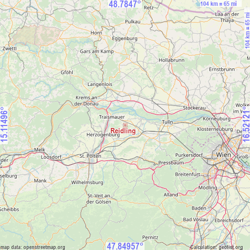
Reidling GPS coordinates[2]
48° 19' 9.408" North, 15° 49' 5.088" East
| Map corner | latitude | longitude |
|---|---|---|
| Upper-left | 48.7847°, | 15.11496° |
| Center: | 48.31928°, | 15.81808° |
| Lower-right: | 47.84957°, | 16.52121° |
| Map W x H: | 104×104 km | = 64.6×64.6mi |
| max Lat: | 48.98333° ⇑13.2% North |
| Reidling: | 48.31928° |
| min Lat: | ⇓86.8% South 46.48841° |
| min Long | Reidling | max Long |
| 9.57802° | 15.81808° | 17.1° |
| W 75.3%⇐ | ⇒24.7% E |
Elevation
Elevation of Reidling is 194 m = 636 ft, and this is 311.5 m = 1022 ft below average elevation for this country.
| Max E: |
2140 m = 7021 ft | 92.8% |
| Avg. | 505.5 m = 1658 ft | |
| Reidling | 194 m = 636 ft | |
Min E: |
118 m = 387 ft | 7.2% |
See also: Austria elevation on elevation.city.
Geographical zone
Reidling is located in North temperate zone (between Tropic of Cancer and the Arctic Circle). Distance of this North polar circle is 2028.6 km =1260.5 mi to North.| Distance of | km | miles | from Reidling |
|---|---|---|---|
| North Pole | 4634.5 | 2879.7 | to North |
| Arctic Circle | 2028.6 | 1260.5 | to North |
| Tropic Cancer | 2766.7 | 1719.1 | to South |
| Equator | 5372.6 | 3338.4 | to South |


Nearby cities:
15 places around Reidling: (largest is in red/bold)
• Atzenbrugg
7.2 km =4.5 mi,  115°
115°
• Erpersdorf
7.8 km =4.8 mi,  70°
70°
• Etzersdorf
7.7 km =4.8 mi,  220°
220°
• Gemeinlebarn
2.1 km =1.3 mi,  333°
333°
• Getzersdorf
9.1 km =5.7 mi,  276°
276°
• Heiligeneich
6 km =3.7 mi,  111°
111°
• Kapelln
8.1 km =5 mi,  213°
213°
• Reichersdorf
9.1 km =5.7 mi, 283°
• Sankt Andrä an der Traisen
7.9 km =4.9 mi,  251°
251°
• Stollhofen
5.7 km =3.5 mi,  310°
310°
• Traismauer
7.1 km =4.4 mi,  298°
298°
• Trasdorf
4.5 km =2.8 mi,  99°
99°
• Wagram ob der Traisen
9.2 km =5.7 mi, 301°
• Würmla
7.8 km =4.8 mi,  156°
156°
• Zwentendorf
7.4 km =4.6 mi, 66°
Sources, notices
• [Note1] Compared only with cities in Austria existing in our database
• [Src1] Map data: © OpenStreetMap contributors (CC-BY-SA)
• [Src2] Other city data from geonames.org with taken over terms of usage.
• [Src3] Geographical zone / Annual Mean Temperature by Robert A. Rohde @ Wikipedia
