Würmla geodata
Würmla (Lower Austria) is a seat of a third-order administrative division; located in Austria in Europe/Vienna (GMT+2) time zone. With population of 669 people, there are 1936 cities with bigger population in this country. Compared to other cities in Austria, 83.1% of cities are located further ↓South; 76.3% of cities are located further ←West and 88% of cities have higher elevation than Würmla. Note1
Administrative division(s):
- Level 1: Lower Austria
- Level 2: Politischer Bezirk Tulln
- Level 3: Würmla


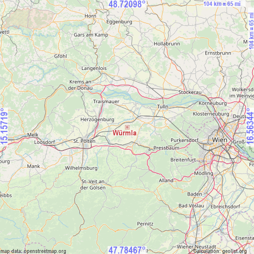
Würmla GPS coordinates[2]
48° 15' 17.892" North, 15° 51' 37.116" East
| Map corner | latitude | longitude |
|---|---|---|
| Upper-left | 48.72098°, | 15.15719° |
| Center: | 48.25497°, | 15.86031° |
| Lower-right: | 47.78467°, | 16.56344° |
| Map W x H: | 104.1×104.1 km | = 64.7×64.7mi |
| max Lat: | 48.98333° ⇑16.9% North |
| Würmla: | 48.25497° |
| min Lat: | ⇓83.1% South 46.48841° |
| min Long | Würmla | max Long |
| 9.57802° | 15.86031° | 17.1° |
| W 76.3%⇐ | ⇒23.7% E |
Elevation
Elevation of Würmla is 229 m = 751 ft, and this is 276.5 m = 907 ft below average elevation for this country.
| Max E: |
2140 m = 7021 ft | 88% |
| Avg. | 505.5 m = 1658 ft | |
| Würmla | 229 m = 751 ft | |
Min E: |
118 m = 387 ft | 12% |
See also: Austria elevation on elevation.city.
Geographical zone
Würmla is located in North temperate zone (between Tropic of Cancer and the Arctic Circle). Distance of this North polar circle is 2035.7 km =1264.9 mi to North.| Distance of | km | miles | from Würmla |
|---|---|---|---|
| North Pole | 4641.6 | 2884.2 | to North |
| Arctic Circle | 2035.7 | 1264.9 | to North |
| Tropic Cancer | 2759.5 | 1714.7 | to South |
| Equator | 5365.4 | 3333.9 | to South |


Nearby cities:
15 places around Würmla: (largest is in red/bold)
• Asperhofen
5 km =3.1 mi,  101°
101°
• Atzenbrugg
5.3 km =3.3 mi,  40°
40°
• Au am Anzbach
7.5 km =4.7 mi,  142°
142°
• Ebersberg
6.9 km =4.3 mi,  160°
160°
• Etzersdorf
8.3 km =5.2 mi,  279°
279°
• Haag
7.8 km =4.8 mi, 157°
• Heiligeneich
5.6 km =3.5 mi,  26°
26°
• Kapelln
7.6 km =4.7 mi,  272°
272°
• Kirchstetten
8.6 km =5.3 mi,  202°
202°
• Maria-Anzbach
8.9 km =5.5 mi, 143°
• Michelhausen
7.1 km =4.4 mi,  55°
55°
• Neulengbach
7.1 km =4.4 mi,  154°
154°
• Ollersbach
7.7 km =4.8 mi,  189°
189°
• Reidling
7.8 km =4.8 mi,  336°
336°
• Trasdorf
6.6 km =4.1 mi,  11°
11°
Sources, notices
• [Note1] Compared only with cities in Austria existing in our database
• [Src1] Map data: © OpenStreetMap contributors (CC-BY-SA)
• [Src2] Other city data from geonames.org with taken over terms of usage.
• [Src3] Geographical zone / Annual Mean Temperature by Robert A. Rohde @ Wikipedia
