Puch geodata
Puch (Carinthia) is a populated place; located in Austria in Europe/Vienna (GMT+2) time zone. With population of 627 people, there are 2044 cities with bigger population in this country. Compared to other cities in Austria, 96.3% of cities are located further ↑North; 70.2% of cities are located further →East and 65% of cities have lower elevation than Puch. Note1
Administrative division(s):
- Level 1: Carinthia
- Level 2: Politischer Bezirk Villach Land
- Level 3: Weißenstein


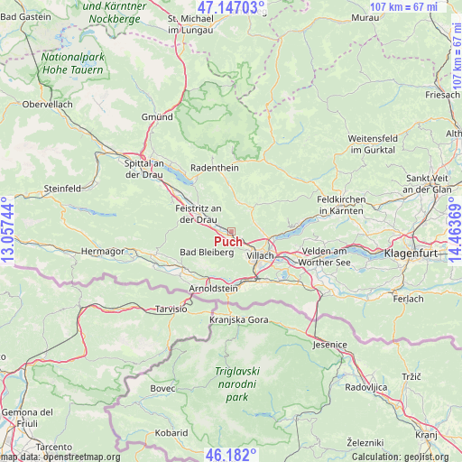
Puch GPS coordinates[2]
46° 40' 0.012" North, 13° 45' 38.016" East
| Map corner | latitude | longitude |
|---|---|---|
| Upper-left | 47.14703°, | 13.05744° |
| Center: | 46.66667°, | 13.76056° |
| Lower-right: | 46.182°, | 14.46369° |
| Map W x H: | 107.3×107.3 km | = 66.7×66.7mi |
| max Lat: | 48.98333° ⇑96.3% North |
| Puch: | 46.66667° |
| min Lat: | ⇓3.7% South 46.48841° |
| min Long | Puch | max Long |
| 9.57802° | 13.76056° | 17.1° |
| W 29.8%⇐ | ⇒70.2% E |
Elevation
Elevation of Puch is 553 m = 1814 ft, and this is 47.5 m = 156 ft above average elevation for this country.
| Max E: |
2140 m = 7021 ft | 35% |
| Puch | 553 m 1814 ft | |
| Avg. | 505.5 m = 1658 ft | |
Min E: |
118 m = 387 ft | 65% |
See also: Austria elevation on elevation.city.
Geographical zone
Puch is located in North temperate zone (between Tropic of Cancer and the Arctic Circle). Distance of this North polar circle is 2212.3 km =1374.7 mi to North.| Distance of | km | miles | from Puch |
|---|---|---|---|
| North Pole | 4818.2 | 2993.9 | to North |
| Arctic Circle | 2212.3 | 1374.7 | to North |
| Tropic Cancer | 2582.9 | 1604.9 | to South |
| Equator | 5188.8 | 3224.2 | to South |


Nearby cities:
15 places around Puch: (largest is in red/bold)
• Feistritz an der Drau
8.3 km =5.2 mi,  297°
297°
• Fresach
7.6 km =4.7 mi,  315°
315°
• Goritschach
7.1 km =4.4 mi,  148°
148°
• Großvassach
8.1 km =5 mi,  122°
122°
• Kleinvassach
8.1 km =5 mi, 119°
• Lind
8.2 km =5.1 mi,  126°
126°
• Neu-Feffernitz
6.6 km =4.1 mi,  290°
290°
• Neufellach
6.5 km =4 mi,  140°
140°
• Obere Fellach
5.6 km =3.5 mi, 138°
• Sankt Georgen
4.8 km =3 mi, 140°
• Sankt Martin
7.6 km =4.7 mi, 136°
• Treffen
7.5 km =4.7 mi,  86°
86°
• Untere Fellach
6.9 km =4.3 mi, 132°
• Völkendorf
8.5 km =5.3 mi, 140°
• Weissenstein
3.1 km =1.9 mi,  312°
312°
Sources, notices
• [Note1] Compared only with cities in Austria existing in our database
• [Src1] Map data: © OpenStreetMap contributors (CC-BY-SA)
• [Src2] Other city data from geonames.org with taken over terms of usage.
• [Src3] Geographical zone / Annual Mean Temperature by Robert A. Rohde @ Wikipedia
