Fresach geodata
Fresach (Carinthia) is a seat of a third-order administrative division; located in Austria in Europe/Vienna (GMT+2) time zone. With population of 560 people, there are 2278 cities with bigger population in this country. Compared to other cities in Austria, 94.9% of cities are located further ↑North; 71.5% of cities are located further →East and 82% of cities have lower elevation than Fresach. Note1
Administrative division(s):
- Level 1: Carinthia
- Level 2: Politischer Bezirk Villach Land
- Level 3: Fresach


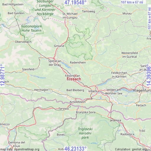
Fresach GPS coordinates[2]
46° 42' 56.016" North, 13° 41' 26.988" East
| Map corner | latitude | longitude |
|---|---|---|
| Upper-left | 47.19548°, | 12.98771° |
| Center: | 46.71556°, | 13.69083° |
| Lower-right: | 46.23133°, | 14.39396° |
| Map W x H: | 107.2×107.2 km | = 66.6×66.6mi |
| max Lat: | 48.98333° ⇑94.9% North |
| Fresach: | 46.71556° |
| min Lat: | ⇓5.1% South 46.48841° |
| min Long | Fresach | max Long |
| 9.57802° | 13.69083° | 17.1° |
| W 28.5%⇐ | ⇒71.5% E |
Elevation
Elevation of Fresach is 751 m = 2464 ft, and this is 245.5 m = 805 ft above average elevation for this country.
| Max E: |
2140 m = 7021 ft | 18% |
| Fresach | 751 m 2464 ft | |
| Avg. | 505.5 m = 1658 ft | |
Min E: |
118 m = 387 ft | 82% |
See also: Austria elevation on elevation.city.
Geographical zone
Fresach is located in North temperate zone (between Tropic of Cancer and the Arctic Circle). Distance of this North polar circle is 2206.9 km =1371.3 mi to North.| Distance of | km | miles | from Fresach |
|---|---|---|---|
| North Pole | 4812.8 | 2990.5 | to North |
| Arctic Circle | 2206.9 | 1371.3 | to North |
| Tropic Cancer | 2588.4 | 1608.4 | to South |
| Equator | 5194.3 | 3227.6 | to South |


Nearby cities:
15 places around Fresach: (largest is in red/bold)
• Arriach
12.3 km =7.6 mi,  82°
82°
• Bleiberg-Kreuth
10.2 km =6.3 mi,  204°
204°
• Döbriach
7.7 km =4.8 mi,  340°
340°
• Feistritz an der Drau
2.5 km =1.6 mi,  231°
231°
• Feld am See
8 km =5 mi,  32°
32°
• Ferndorf
5.4 km =3.4 mi,  295°
295°
• Neu-Feffernitz
3.2 km =2 mi, 196°
• Nikelsdorf
3.6 km =2.2 mi,  252°
252°
• Nötsch bei Bleiberg
10.7 km =6.6 mi, 198°
• Paternion
4.2 km =2.6 mi,  267°
267°
• Puch
7.6 km =4.7 mi,  135°
135°
• Radenthein
9.6 km =6 mi,  9°
9°
• Sankt Georgen
12.4 km =7.7 mi, 137°
• Untertweng
9 km =5.6 mi,  22°
22°
• Weissenstein
4.5 km =2.8 mi, 137°
Sources, notices
• [Note1] Compared only with cities in Austria existing in our database
• [Src1] Map data: © OpenStreetMap contributors (CC-BY-SA)
• [Src2] Other city data from geonames.org with taken over terms of usage.
• [Src3] Geographical zone / Annual Mean Temperature by Robert A. Rohde @ Wikipedia
