Preding geodata
Preding (Styria) is a seat of a third-order administrative division; located in Austria in Europe/Vienna (GMT+2) time zone. With population of 860 people, there are 1502 cities with bigger population in this country. Compared to other cities in Austria, 89.4% of cities are located further ↑North; 63.1% of cities are located further ←West and 69.8% of cities have higher elevation than Preding. Note1
Administrative division(s):
- Level 1: Styria
- Level 2: Politischer Bezirk Deutschlandsberg
- Level 3: Preding


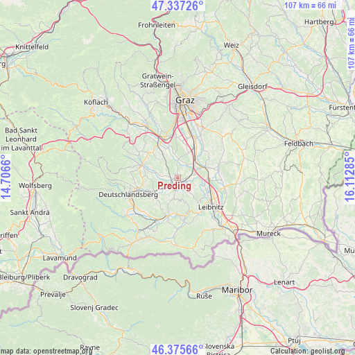
Preding GPS coordinates[2]
46° 51' 30.996" North, 15° 24' 34.992" East
| Map corner | latitude | longitude |
|---|---|---|
| Upper-left | 47.33726°, | 14.7066° |
| Center: | 46.85861°, | 15.40972° |
| Lower-right: | 46.37566°, | 16.11285° |
| Map W x H: | 106.9×106.9 km | = 66.4×66.4mi |
| max Lat: | 48.98333° ⇑89.4% North |
| Preding: | 46.85861° |
| min Lat: | ⇓10.6% South 46.48841° |
| min Long | Preding | max Long |
| 9.57802° | 15.40972° | 17.1° |
| W 63.1%⇐ | ⇒36.9% E |
Elevation
Elevation of Preding is 329 m = 1079 ft, and this is 176.5 m = 579 ft below average elevation for this country.
| Max E: |
2140 m = 7021 ft | 69.8% |
| Avg. | 505.5 m = 1658 ft | |
| Preding | 329 m = 1079 ft | |
Min E: |
118 m = 387 ft | 30.2% |
See also: Austria elevation on elevation.city.
Geographical zone
Preding is located in North temperate zone (between Tropic of Cancer and the Arctic Circle). Distance of this North polar circle is 2191 km =1361.4 mi to North.| Distance of | km | miles | from Preding |
|---|---|---|---|
| North Pole | 4796.9 | 2980.7 | to North |
| Arctic Circle | 2191 | 1361.4 | to North |
| Tropic Cancer | 2604.3 | 1618.2 | to South |
| Equator | 5210.2 | 3237.5 | to South |


Nearby cities:
15 places around Preding: (largest is in red/bold)
• Groß Sankt Florian
7.9 km =4.9 mi,  241°
241°
• Hengsberg
2 km =1.2 mi,  63°
63°
• Kitzeck im Sausal
9.3 km =5.8 mi,  158°
158°
• Lang
7.6 km =4.7 mi,  107°
107°
• Muttendorf
8.9 km =5.5 mi,  338°
338°
• Sankt Josef (Weststeiermark)
7.9 km =4.9 mi,  315°
315°
• Sankt Margarethen bei Lebring
9 km =5.6 mi,  86°
86°
• Sankt Nikolai im Sausal
5.3 km =3.3 mi,  142°
142°
• Tillmitsch
9.7 km =6 mi,  122°
122°
• Unterbergla
9.2 km =5.7 mi,  231°
231°
• Weitendorf
6 km =3.7 mi,  46°
46°
• Werndorf
9.5 km =5.9 mi,  40°
40°
• Wettmannstätten
3.6 km =2.2 mi,  208°
208°
• Wildon
8.6 km =5.3 mi,  71°
71°
• Wundschuh
8.2 km =5.1 mi,  22°
22°
Sources, notices
• [Note1] Compared only with cities in Austria existing in our database
• [Src1] Map data: © OpenStreetMap contributors (CC-BY-SA)
• [Src2] Other city data from geonames.org with taken over terms of usage.
• [Src3] Geographical zone / Annual Mean Temperature by Robert A. Rohde @ Wikipedia
