Wettmannstätten geodata
Wettmannstätten (Styria) is a seat of a third-order administrative division; located in Austria in Europe/Vienna (GMT+2) time zone. With population of 599 people, there are 2144 cities with bigger population in this country. Compared to other cities in Austria, 90.5% of cities are located further ↑North; 62.4% of cities are located further ←West and 75.3% of cities have higher elevation than Wettmannstätten. Note1
Administrative division(s):
- Level 1: Styria
- Level 2: Politischer Bezirk Deutschlandsberg
- Level 3: Wettmannstätten


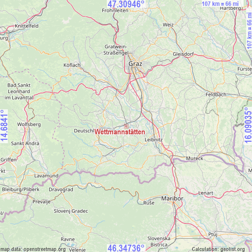
Wettmannstätten GPS coordinates[2]
46° 49' 50.016" North, 15° 23' 13.992" East
| Map corner | latitude | longitude |
|---|---|---|
| Upper-left | 47.30946°, | 14.6841° |
| Center: | 46.83056°, | 15.38722° |
| Lower-right: | 46.34736°, | 16.09035° |
| Map W x H: | 107×107 km | = 66.5×66.5mi |
| max Lat: | 48.98333° ⇑90.5% North |
| Wettmannstätten: | 46.83056° |
| min Lat: | ⇓9.5% South 46.48841° |
| min Long | Wettmannstätte | max Long |
| 9.57802° | 15.38722° | 17.1° |
| W 62.4%⇐ | ⇒37.6% E |
Elevation
Elevation of Wettmannstätten is 301 m = 988 ft, and this is 204.5 m = 671 ft below average elevation for this country.
| Max E: |
2140 m = 7021 ft | 75.3% |
| Avg. | 505.5 m = 1658 ft | |
| Wettmannstätten | 301 m = 988 ft | |
Min E: |
118 m = 387 ft | 24.7% |
See also: Austria elevation on elevation.city.
Geographical zone
Wettmannstätten is located in North temperate zone (between Tropic of Cancer and the Arctic Circle). Distance of this North polar circle is 2194.1 km =1363.4 mi to North.| Distance of | km | miles | from Wettmannstätten |
|---|---|---|---|
| North Pole | 4800 | 2982.6 | to North |
| Arctic Circle | 2194.1 | 1363.4 | to North |
| Tropic Cancer | 2601.2 | 1616.3 | to South |
| Equator | 5207.1 | 3235.5 | to South |


Nearby cities:
15 places around Wettmannstätten: (largest is in red/bold)
• Gleinstätten
8.7 km =5.4 mi,  188°
188°
• Graschuh
10.3 km =6.4 mi,  303°
303°
• Groß Sankt Florian
5.3 km =3.3 mi,  262°
262°
• Hengsberg
5.3 km =3.3 mi,  41°
41°
• Kitzeck im Sausal
7.5 km =4.7 mi,  137°
137°
• Lang
9 km =5.6 mi,  84°
84°
• Pistorf
7.3 km =4.5 mi, 192°
• Preding
3.6 km =2.2 mi,  28°
28°
• Rassach
9.5 km =5.9 mi,  290°
290°
• Sankt Josef (Weststeiermark)
9.6 km =6 mi,  336°
336°
• Sankt Nikolai im Sausal
5 km =3.1 mi,  102°
102°
• Stallhof
9.8 km =6.1 mi,  306°
306°
• Tillmitsch
10.1 km =6.3 mi, 101°
• Unterbergla
6.1 km =3.8 mi,  244°
244°
• Weitendorf
9.5 km =5.9 mi, 39°
Sources, notices
• [Note1] Compared only with cities in Austria existing in our database
• [Src1] Map data: © OpenStreetMap contributors (CC-BY-SA)
• [Src2] Other city data from geonames.org with taken over terms of usage.
• [Src3] Geographical zone / Annual Mean Temperature by Robert A. Rohde @ Wikipedia
