Prätis geodata
Prätis (Styria) is a populated place; located in Austria in Europe/Vienna (GMT+2) time zone. With population of 569 people, there are 2249 cities with bigger population in this country. Compared to other cities in Austria, 63% of cities are located further ↑North; 75% of cities are located further ←West and 71% of cities have lower elevation than Prätis. Note1
Administrative division(s):
- Level 1: Styria
- Level 2: Politischer Bezirk Hartberg-Fürstenfeld
- Level 3: Pöllau


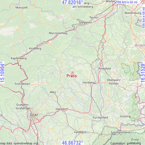
Prätis GPS coordinates[2]
47° 20' 45.204" North, 15° 48' 43.776" East
| Map corner | latitude | longitude |
|---|---|---|
| Upper-left | 47.82016°, | 15.10904° |
| Center: | 47.34589°, | 15.81216° |
| Lower-right: | 46.86732°, | 16.51529° |
| Map W x H: | 105.9×105.9 km | = 65.8×65.8mi |
| max Lat: | 48.98333° ⇑63% North |
| Prätis: | 47.34589° |
| min Lat: | ⇓37% South 46.48841° |
| min Long | Prätis | max Long |
| 9.57802° | 15.81216° | 17.1° |
| W 75%⇐ | ⇒25% E |
Elevation
Elevation of Prätis is 600 m = 1969 ft, and this is 94.5 m = 310 ft above average elevation for this country.
| Max E: |
2140 m = 7021 ft | 29% |
| Prätis | 600 m 1969 ft | |
| Avg. | 505.5 m = 1658 ft | |
Min E: |
118 m = 387 ft | 71% |
See also: Austria elevation on elevation.city.
Geographical zone
Prätis is located in North temperate zone (between Tropic of Cancer and the Arctic Circle). Distance of this North polar circle is 2136.8 km =1327.7 mi to North.| Distance of | km | miles | from Prätis |
|---|---|---|---|
| North Pole | 4742.7 | 2947 | to North |
| Arctic Circle | 2136.8 | 1327.7 | to North |
| Tropic Cancer | 2658.5 | 1651.9 | to South |
| Equator | 5264.4 | 3271.1 | to South |


Nearby cities:
15 places around Prätis: (largest is in red/bold)
• Gschaid bei Birkfeld
8.3 km =5.2 mi,  274°
274°
• Miesenbach bei Birkfeld
4.1 km =2.5 mi,  303°
303°
• Oberneuberg
5.2 km =3.2 mi,  128°
128°
• Obersaifen
3.9 km =2.4 mi,  213°
213°
• Pittermann
8.2 km =5.1 mi,  344°
344°
• Pongrazen bei Hartberg
7.4 km =4.6 mi,  93°
93°
• Puchegg
7 km =4.3 mi,  56°
56°
• Pöllau
5.3 km =3.3 mi,  162°
162°
• Pöllauberg
4.3 km =2.7 mi,  138°
138°
• Rabenwald
8.9 km =5.5 mi,  47°
47°
• Schachen bei Vorau
5.1 km =3.2 mi,  42°
42°
• Unterneuberg
4.3 km =2.7 mi, 138°
• Vorau
8.7 km =5.4 mi, 40°
• Vornholz
5.8 km =3.6 mi,  10°
10°
• Zeil-Pöllau
3.2 km =2 mi, 141°
Sources, notices
• [Note1] Compared only with cities in Austria existing in our database
• [Src1] Map data: © OpenStreetMap contributors (CC-BY-SA)
• [Src2] Other city data from geonames.org with taken over terms of usage.
• [Src3] Geographical zone / Annual Mean Temperature by Robert A. Rohde @ Wikipedia
