Gschaid bei Birkfeld geodata
Gschaid bei Birkfeld (Styria) is a populated place; located in Austria in Europe/Vienna (GMT+2) time zone. With population of 881 people, there are 1467 cities with bigger population in this country. Compared to other cities in Austria, 62.2% of cities are located further ↑North; 72.2% of cities are located further ←West and 69.9% of cities have lower elevation than Gschaid bei Birkfeld. Note1


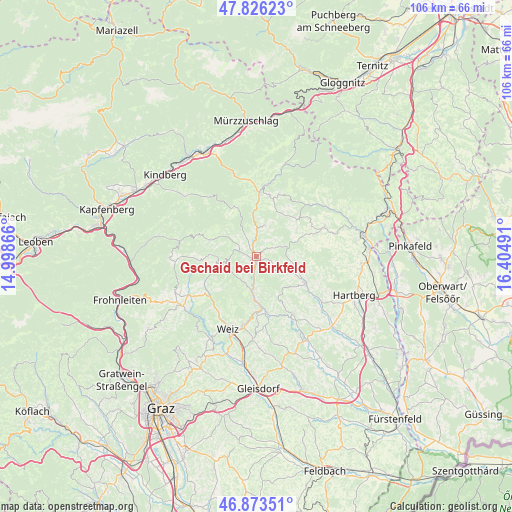
Gschaid bei Birkfeld GPS coordinates[2]
47° 21' 7.272" North, 15° 42' 6.408" East
| Map corner | latitude | longitude |
|---|---|---|
| Upper-left | 47.82623°, | 14.99866° |
| Center: | 47.35202°, | 15.70178° |
| Lower-right: | 46.87351°, | 16.40491° |
| Map W x H: | 105.9×105.9 km | = 65.8×65.8mi |
| max Lat: | 48.98333° ⇑62.2% North |
| Gschaid bei Birkfeld: | 47.35202° |
| min Lat: | ⇓37.8% South 46.48841° |
| min Long | Gschaid bei Bir | max Long |
| 9.57802° | 15.70178° | 17.1° |
| W 72.2%⇐ | ⇒27.8% E |
Elevation
Elevation of Gschaid bei Birkfeld is 588 m = 1929 ft, and this is 82.5 m = 271 ft above average elevation for this country.
| Max E: |
2140 m = 7021 ft | 30.1% |
| Gschaid bei Birkfeld | 588 m 1929 ft | |
| Avg. | 505.5 m = 1658 ft | |
Min E: |
118 m = 387 ft | 69.9% |
See also: Austria elevation on elevation.city.
Geographical zone
Gschaid bei Birkfeld is located in North temperate zone (between Tropic of Cancer and the Arctic Circle). Distance of this North polar circle is 2136.1 km =1327.3 mi to North.| Distance of | km | miles | from Gschaid bei Birkfeld |
|---|---|---|---|
| North Pole | 4742 | 2946.5 | to North |
| Arctic Circle | 2136.1 | 1327.3 | to North |
| Tropic Cancer | 2659.1 | 1652.3 | to South |
| Equator | 5265.1 | 3271.6 | to South |


Nearby cities:
15 places around Gschaid bei Birkfeld: (largest is in red/bold)
• Anger
8.7 km =5.4 mi,  185°
185°
• Baierdorf-Umgebung
7.5 km =4.7 mi,  174°
174°
• Birkfeld
1.4 km =0.9 mi,  260°
260°
• Floing
10.4 km =6.5 mi,  161°
161°
• Miesenbach bei Birkfeld
5.2 km =3.2 mi,  71°
71°
• Obersaifen
7.3 km =4.5 mi,  122°
122°
• Pittermann
9.5 km =5.9 mi,  40°
40°
• Prätis
8.3 km =5.2 mi,  94°
94°
• Sankt Kathrein am Offenegg
10.6 km =6.6 mi,  237°
237°
• Sankt Kathrein am Offenegg I Viertel
10.8 km =6.7 mi, 235°
• Sankt Kathrein am Offenegg II Viertel
10.5 km =6.5 mi,  254°
254°
• Strallegg
6.9 km =4.3 mi,  14°
14°
• Vornholz
10.6 km =6.6 mi,  61°
61°
• Waisenegg
4.9 km =3 mi,  343°
343°
• Zeil-Pöllau
10.7 km =6.6 mi,  107°
107°
Sources, notices
• [Note1] Compared only with cities in Austria existing in our database
• [Src1] Map data: © OpenStreetMap contributors (CC-BY-SA)
• [Src2] Other city data from geonames.org with taken over terms of usage.
• [Src3] Geographical zone / Annual Mean Temperature by Robert A. Rohde @ Wikipedia
