Großklein geodata
Großklein (Styria) is a seat of a third-order administrative division; located in Austria in Europe/Vienna (GMT+2) time zone. With population of 639 people, there are 2012 cities with bigger population in this country. Compared to other cities in Austria, 94.1% of cities are located further ↑North; 63.8% of cities are located further ←West and 69.5% of cities have higher elevation than Großklein. Note1


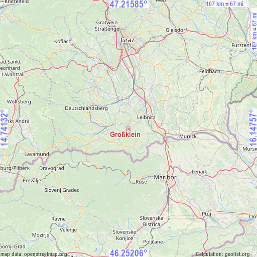
Großklein GPS coordinates[2]
46° 44' 9.996" North, 15° 26' 39.984" East
| Map corner | latitude | longitude |
|---|---|---|
| Upper-left | 47.21585°, | 14.74132° |
| Center: | 46.73611°, | 15.44444° |
| Lower-right: | 46.25206°, | 16.14757° |
| Map W x H: | 107.2×107.2 km | = 66.6×66.6mi |
| max Lat: | 48.98333° ⇑94.1% North |
| Großklein: | 46.73611° |
| min Lat: | ⇓5.9% South 46.48841° |
| min Long | Großklein | max Long |
| 9.57802° | 15.44444° | 17.1° |
| W 63.8%⇐ | ⇒36.2% E |
Elevation
Elevation of Großklein is 330 m = 1083 ft, and this is 175.5 m = 576 ft below average elevation for this country.
| Max E: |
2140 m = 7021 ft | 69.5% |
| Avg. | 505.5 m = 1658 ft | |
| Großklein | 330 m = 1083 ft | |
Min E: |
118 m = 387 ft | 30.5% |
See also: Austria elevation on elevation.city.
Geographical zone
Großklein is located in North temperate zone (between Tropic of Cancer and the Arctic Circle). Distance of this North polar circle is 2204.6 km =1369.9 mi to North.| Distance of | km | miles | from Großklein |
|---|---|---|---|
| North Pole | 4810.5 | 2989.1 | to North |
| Arctic Circle | 2204.6 | 1369.9 | to North |
| Tropic Cancer | 2590.6 | 1609.7 | to South |
| Equator | 5196.6 | 3229 | to South |


Nearby cities:
15 places around Großklein: (largest is in red/bold)
• Arnfels
7.4 km =4.6 mi,  205°
205°
• Eichberg-Trautenburg
4.9 km =3 mi,  172°
172°
• Fötschach
6.6 km =4.1 mi,  153°
153°
• Gamlitz
8.5 km =5.3 mi,  101°
101°
• Gleinstätten
6 km =3.7 mi,  288°
288°
• Heimschuh
4.6 km =2.9 mi,  54°
54°
• Kitzeck im Sausal
5 km =3.1 mi,  8°
8°
• Leibnitz
8.8 km =5.5 mi, 54°
• Leutschach
7.9 km =4.9 mi, 166°
• Pistorf
6.8 km =4.2 mi,  299°
299°
• Retznei
9.3 km =5.8 mi,  91°
91°
• Sankt Johann im Saggautal
4.8 km =3 mi,  221°
221°
• Seggauberg
6.5 km =4 mi,  58°
58°
• Untergreith
7.5 km =4.7 mi,  253°
253°
• Wagna
9.4 km =5.8 mi,  68°
68°
Sources, notices
• [Note1] Compared only with cities in Austria existing in our database
• [Src1] Map data: © OpenStreetMap contributors (CC-BY-SA)
• [Src2] Other city data from geonames.org with taken over terms of usage.
• [Src3] Geographical zone / Annual Mean Temperature by Robert A. Rohde @ Wikipedia
