Pertisau geodata
Pertisau (Tyrol) is a populated place; located in Austria in Europe/Vienna (GMT+2) time zone. With population of 713 people, there are 1826 cities with bigger population in this country. Compared to other cities in Austria, 57.3% of cities are located further ↑North; 90.5% of cities are located further →East and 92.8% of cities have lower elevation than Pertisau. Note1
Administrative division(s):
- Level 1: Tyrol
- Level 2: Politischer Bezirk Schwaz
- Level 3: Eben am Achensee


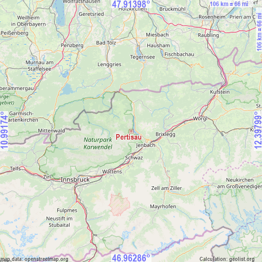
Pertisau GPS coordinates[2]
47° 26' 26.052" North, 11° 41' 41.496" East
| Map corner | latitude | longitude |
|---|---|---|
| Upper-left | 47.91398°, | 10.99174° |
| Center: | 47.44057°, | 11.69486° |
| Lower-right: | 46.96286°, | 12.39799° |
| Map W x H: | 105.8×105.8 km | = 65.7×65.7mi |
| max Lat: | 48.98333° ⇑57.3% North |
| Pertisau: | 47.44057° |
| min Lat: | ⇓42.7% South 46.48841° |
| min Long | Pertisau | max Long |
| 9.57802° | 11.69486° | 17.1° |
| W 9.5%⇐ | ⇒90.5% E |
Elevation
Elevation of Pertisau is 950 m = 3117 ft, and this is 444.5 m = 1458 ft above average elevation for this country.
| Max E: |
2140 m = 7021 ft | 7.2% |
| Pertisau | 950 m 3117 ft | |
| Avg. | 505.5 m = 1658 ft | |
Min E: |
118 m = 387 ft | 92.8% |
See also: Austria elevation on elevation.city.
Geographical zone
Pertisau is located in North temperate zone (between Tropic of Cancer and the Arctic Circle). Distance of this North polar circle is 2126.3 km =1321.2 mi to North.| Distance of | km | miles | from Pertisau |
|---|---|---|---|
| North Pole | 4732.2 | 2940.5 | to North |
| Arctic Circle | 2126.3 | 1321.2 | to North |
| Tropic Cancer | 2669 | 1658.4 | to South |
| Equator | 5274.9 | 3277.7 | to South |


Nearby cities:
15 places around Pertisau: (largest is in red/bold)
• Achenkirch
9.6 km =6 mi,  4°
4°
• Buch in Tirol
8.6 km =5.3 mi,  148°
148°
• Eben am Achensee
5.8 km =3.6 mi,  120°
120°
• Fiecht
10.1 km =6.3 mi,  177°
177°
• Gallzein
9.9 km =6.2 mi,  144°
144°
• Jenbach
8 km =5 mi,  132°
132°
• Maurach
4.9 km =3 mi, 116°
• Münster
10.6 km =6.6 mi,  101°
101°
• Rofansiedlung
8.9 km =5.5 mi,  112°
112°
• Schwaz
9.9 km =6.2 mi,  173°
173°
• Stans
8.4 km =5.2 mi, 168°
• Strass im Zillertal
10.6 km =6.6 mi, 118°
• Vomp
12 km =7.5 mi, 184°
• Vomperbach
12.1 km =7.5 mi,  190°
190°
• Wiesing
8.7 km =5.4 mi, 117°
Sources, notices
• [Note1] Compared only with cities in Austria existing in our database
• [Src1] Map data: © OpenStreetMap contributors (CC-BY-SA)
• [Src2] Other city data from geonames.org with taken over terms of usage.
• [Src3] Geographical zone / Annual Mean Temperature by Robert A. Rohde @ Wikipedia
