Muggendorf geodata
Muggendorf (Lower Austria) is a seat of a third-order administrative division; located in Austria in Europe/Vienna (GMT+2) time zone. With population of 365 people, there are 2664 cities with bigger population in this country. Compared to other cities in Austria, 61.5% of cities are located further ↓South; 78.5% of cities are located further ←West and 50.1% of cities have higher elevation than Muggendorf. Note1
Administrative division(s):
- Level 1: Lower Austria
- Level 2: Politischer Bezirk Wiener Neustadt
- Level 3: Muggendorf


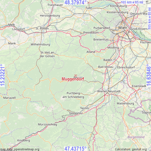
Muggendorf GPS coordinates[2]
47° 54' 38.124" North, 15° 56' 7.188" East
| Map corner | latitude | longitude |
|---|---|---|
| Upper-left | 48.37974°, | 15.23221° |
| Center: | 47.91059°, | 15.93533° |
| Lower-right: | 47.43715°, | 16.63846° |
| Map W x H: | 104.8×104.8 km | = 65.1×65.1mi |
| max Lat: | 48.98333° ⇑38.5% North |
| Muggendorf: | 47.91059° |
| min Lat: | ⇓61.5% South 46.48841° |
| min Long | Muggendorf | max Long |
| 9.57802° | 15.93533° | 17.1° |
| W 78.5%⇐ | ⇒21.5% E |
Elevation
Elevation of Muggendorf is 450 m = 1476 ft, and this is 55.5 m = 182 ft below average elevation for this country.
| Max E: |
2140 m = 7021 ft | 50.1% |
| Avg. | 505.5 m = 1658 ft | |
| Muggendorf | 450 m = 1476 ft | |
Min E: |
118 m = 387 ft | 49.9% |
See also: Austria elevation on elevation.city.
Geographical zone
Muggendorf is located in North temperate zone (between Tropic of Cancer and the Arctic Circle). Distance of this North polar circle is 2074 km =1288.7 mi to North.| Distance of | km | miles | from Muggendorf |
|---|---|---|---|
| North Pole | 4679.9 | 2908 | to North |
| Arctic Circle | 2074 | 1288.7 | to North |
| Tropic Cancer | 2721.2 | 1690.9 | to South |
| Equator | 5327.2 | 3310.2 | to South |


Nearby cities:
15 places around Muggendorf: (largest is in red/bold)
• Altenmarkt an der Triesting
12.5 km =7.8 mi,  21°
21°
• Furth an der Triesting
7.5 km =4.7 mi, 22°
• Gutenstein
5.2 km =3.2 mi,  222°
222°
• Hernstein
12.8 km =8 mi,  97°
97°
• Kaumberg
12.9 km =8 mi,  347°
347°
• Miesenbach
8.6 km =5.3 mi,  155°
155°
• Neuhaus
12.5 km =7.8 mi,  41°
41°
• Neusiedl
3.3 km =2.1 mi,  140°
140°
• Oberpiesting
12.8 km =8 mi,  107°
107°
• Pernitz
2.4 km =1.5 mi,  127°
127°
• Thenneberg
12 km =7.5 mi,  10°
10°
• Vorderbruck
4.2 km =2.6 mi,  209°
209°
• Waidmannsfeld
5.6 km =3.5 mi, 142°
• Waldegg
9.8 km =6.1 mi,  118°
118°
• Weissenbach an der Triesting
11.1 km =6.9 mi, 44°
Sources, notices
• [Note1] Compared only with cities in Austria existing in our database
• [Src1] Map data: © OpenStreetMap contributors (CC-BY-SA)
• [Src2] Other city data from geonames.org with taken over terms of usage.
• [Src3] Geographical zone / Annual Mean Temperature by Robert A. Rohde @ Wikipedia
