Köflach geodata
Köflach (Styria) is a seat of a third-order administrative division; located in Austria in Europe/Vienna (GMT+2) time zone. With population of 4,375 people, there are 227 cities with bigger population in this country. Compared to other cities in Austria, 81.3% of cities are located further ↑North; 55.5% of cities are located further ←West and 50.2% of cities have lower elevation than Köflach. Note1


Köflach GPS coordinates[2]
47° 4' 0.012" North, 15° 4' 59.988" East
| Map corner | latitude | longitude |
|---|---|---|
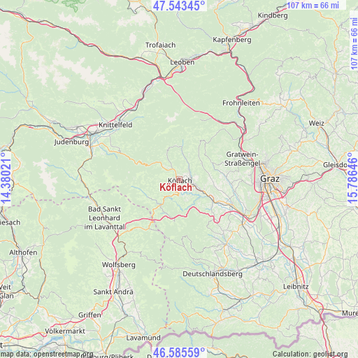
| Upper-left | 47.54345°, | 14.38021° |
| Center: | 47.06667°, | 15.08333° |
| Lower-right: | 46.58559°, | 15.78646° |
| Map W x H: | 106.5×106.5 km | = 66.2×66.2mi |
| max Lat: | 48.98333° ⇑81.3% North |
| Köflach: | 47.06667° |
| min Lat: | ⇓18.7% South 46.48841° |
| min Long | Köflach | max Long |
| 9.57802° | 15.08333° | 17.1° |
| W 55.5%⇐ | ⇒44.5% E |
Elevation
Elevation of Köflach is 451 m = 1480 ft, and this is 54.5 m = 179 ft below average elevation for this country.
| Max E: |
2140 m = 7021 ft | 49.8% |
| Avg. | 505.5 m = 1658 ft | |
| Köflach | 451 m = 1480 ft | |
Min E: |
118 m = 387 ft | 50.2% |
See also: Austria elevation on elevation.city.
Geographical zone
Köflach is located in North temperate zone (between Tropic of Cancer and the Arctic Circle). Distance of this North polar circle is 2167.9 km =1347.1 mi to North.| Distance of | km | miles | from Köflach |
|---|---|---|---|
| North Pole | 4773.7 | 2966.2 | to North |
| Arctic Circle | 2167.9 | 1347.1 | to North |
| Tropic Cancer | 2627.4 | 1632.6 | to South |
| Equator | 5233.3 | 3251.8 | to South |


Nearby cities:
15 places around Köflach: (largest is in red/bold)
• Bärnbach
3.4 km =2.1 mi,  81°
81°
• Edelschrott
5.5 km =3.4 mi,  204°
204°
• Gradenberg
1.6 km =1 mi,  322°
322°
• Hochtregist
5.3 km =3.3 mi,  45°
45°
• Kainach bei Voitsberg
7.8 km =4.8 mi,  6°
6°
• Kleingaisfeld
10.7 km =6.6 mi,  115°
115°
• Kohlschwarz
6.1 km =3.8 mi,  24°
24°
• Maria Lankowitz
1.5 km =0.9 mi,  250°
250°
• Piberegg
4 km =2.5 mi,  39°
39°
• Pichling bei Köflach
2.3 km =1.4 mi, 204°
• Rosental an der Kainach
3.4 km =2.1 mi, 119°
• Salla
9.6 km =6 mi,  292°
292°
• Stallhofen
10.3 km =6.4 mi,  100°
100°
• Södingberg
8.1 km =5 mi,  56°
56°
• Voitsberg
5.8 km =3.6 mi, 115°
Sources, notices
• [Note1] Compared only with cities in Austria existing in our database
• [Src1] Map data: © OpenStreetMap contributors (CC-BY-SA)
• [Src2] Other city data from geonames.org with taken over terms of usage.
• [Src3] Geographical zone / Annual Mean Temperature by Robert A. Rohde @ Wikipedia
