Bärnbach geodata
Bärnbach (Styria) is a populated place; located in Austria in Europe/Vienna (GMT+2) time zone. With population of 4,178 people, there are 244 cities with bigger population in this country. Compared to other cities in Austria, 80.7% of cities are located further ↑North; 56.4% of cities are located further ←West and 54.1% of cities have higher elevation than Bärnbach. Note1


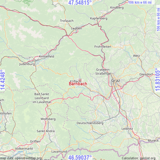
Bärnbach GPS coordinates[2]
47° 4' 17.076" North, 15° 7' 40.512" East
| Map corner | latitude | longitude |
|---|---|---|
| Upper-left | 47.54815°, | 14.4248° |
| Center: | 47.07141°, | 15.12792° |
| Lower-right: | 46.59037°, | 15.83105° |
| Map W x H: | 106.5×106.5 km | = 66.2×66.2mi |
| max Lat: | 48.98333° ⇑80.7% North |
| Bärnbach: | 47.07141° |
| min Lat: | ⇓19.3% South 46.48841° |
| min Long | Bärnbach | max Long |
| 9.57802° | 15.12792° | 17.1° |
| W 56.4%⇐ | ⇒43.6% E |
Elevation
Elevation of Bärnbach is 426 m = 1398 ft, and this is 79.5 m = 261 ft below average elevation for this country.
| Max E: |
2140 m = 7021 ft | 54.1% |
| Avg. | 505.5 m = 1658 ft | |
| Bärnbach | 426 m = 1398 ft | |
Min E: |
118 m = 387 ft | 45.9% |
See also: Austria elevation on elevation.city.
Geographical zone
Bärnbach is located in North temperate zone (between Tropic of Cancer and the Arctic Circle). Distance of this North polar circle is 2167.3 km =1346.7 mi to North.| Distance of | km | miles | from Bärnbach |
|---|---|---|---|
| North Pole | 4773.2 | 2965.9 | to North |
| Arctic Circle | 2167.3 | 1346.7 | to North |
| Tropic Cancer | 2627.9 | 1632.9 | to South |
| Equator | 5233.9 | 3252.2 | to South |


Nearby cities:
15 places around Bärnbach: (largest is in red/bold)
• Edelschrott
8 km =5 mi,  225°
225°
• Gradenberg
4.4 km =2.7 mi,  279°
279°
• Hochtregist
3.2 km =2 mi,  7°
7°
• Kainach bei Voitsberg
7.6 km =4.7 mi,  341°
341°
• Kleingaisfeld
8.1 km =5 mi,  129°
129°
• Kohlschwarz
5.1 km =3.2 mi,  350°
350°
• Köflach
3.4 km =2.1 mi,  261°
261°
• Maria Lankowitz
4.9 km =3 mi, 257°
• Piberegg
2.7 km =1.7 mi, 341°
• Pichling bei Köflach
5 km =3.1 mi,  238°
238°
• Rosental an der Kainach
2.2 km =1.4 mi,  191°
191°
• Stallhofen
7.1 km =4.4 mi,  109°
109°
• Stiwoll
7.4 km =4.6 mi,  64°
64°
• Södingberg
5.2 km =3.2 mi,  39°
39°
• Voitsberg
3.6 km =2.2 mi,  147°
147°
Sources, notices
• [Note1] Compared only with cities in Austria existing in our database
• [Src1] Map data: © OpenStreetMap contributors (CC-BY-SA)
• [Src2] Other city data from geonames.org with taken over terms of usage.
• [Src3] Geographical zone / Annual Mean Temperature by Robert A. Rohde @ Wikipedia
