Obere Klaus geodata
Obere Klaus (Styria) is a populated place; located in Austria in Europe/Vienna (GMT+2) time zone. With population of 977 people, there are 1327 cities with bigger population in this country. Compared to other cities in Austria, 60.2% of cities are located further ↑North; 72.4% of cities are located further →East and 84.9% of cities have lower elevation than Obere Klaus. Note1


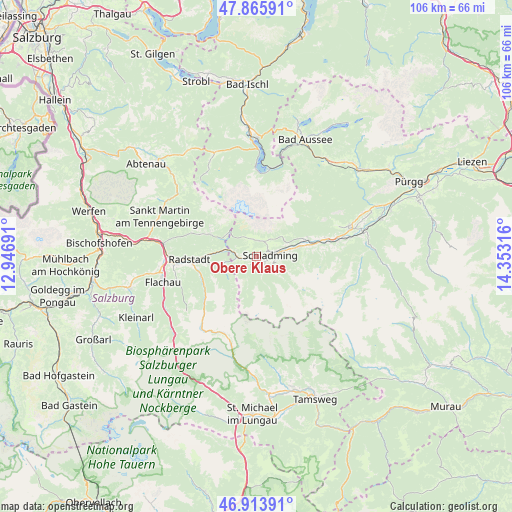
Obere Klaus GPS coordinates[2]
47° 23' 31.416" North, 13° 39' 0.108" East
| Map corner | latitude | longitude |
|---|---|---|
| Upper-left | 47.86591°, | 12.94691° |
| Center: | 47.39206°, | 13.65003° |
| Lower-right: | 46.91391°, | 14.35316° |
| Map W x H: | 105.9×105.9 km | = 65.8×65.8mi |
| max Lat: | 48.98333° ⇑60.2% North |
| Obere Klaus: | 47.39206° |
| min Lat: | ⇓39.8% South 46.48841° |
| min Long | Obere Klaus | max Long |
| 9.57802° | 13.65003° | 17.1° |
| W 27.6%⇐ | ⇒72.4% E |
Elevation
Elevation of Obere Klaus is 796 m = 2612 ft, and this is 290.5 m = 953 ft above average elevation for this country.
| Max E: |
2140 m = 7021 ft | 15.1% |
| Obere Klaus | 796 m 2612 ft | |
| Avg. | 505.5 m = 1658 ft | |
Min E: |
118 m = 387 ft | 84.9% |
See also: Austria elevation on elevation.city.
Geographical zone
Obere Klaus is located in North temperate zone (between Tropic of Cancer and the Arctic Circle). Distance of this North polar circle is 2131.7 km =1324.6 mi to North.| Distance of | km | miles | from Obere Klaus |
|---|---|---|---|
| North Pole | 4737.6 | 2943.8 | to North |
| Arctic Circle | 2131.7 | 1324.6 | to North |
| Tropic Cancer | 2663.6 | 1655.1 | to South |
| Equator | 5269.5 | 3274.3 | to South |


Nearby cities:
15 places around Obere Klaus: (largest is in red/bold)
• Aich
13.3 km =8.3 mi,  75°
75°
• Filzmoos
11 km =6.8 mi,  294°
294°
• Forstau
7.3 km =4.5 mi,  257°
257°
• Gössenberg
12.8 km =8 mi, 77°
• Haus
9 km =5.6 mi, 77°
• Haus im Ennstal
9.1 km =5.7 mi, 76°
• Löbenau
12.6 km =7.8 mi,  265°
265°
• Neuberg
14.1 km =8.8 mi,  297°
297°
• Pichl
3.9 km =2.4 mi, 255°
• Radstadt
15.1 km =9.4 mi, 266°
• Ramsau am Dachstein
3.3 km =2.1 mi,  7°
7°
• Rohrmoos
1.8 km =1.1 mi,  122°
122°
• Schladming
2.8 km =1.7 mi,  88°
88°
• Schwemmberg
12.6 km =7.8 mi, 272°
• Weißenbach
10.3 km =6.4 mi,  70°
70°
Sources, notices
• [Note1] Compared only with cities in Austria existing in our database
• [Src1] Map data: © OpenStreetMap contributors (CC-BY-SA)
• [Src2] Other city data from geonames.org with taken over terms of usage.
• [Src3] Geographical zone / Annual Mean Temperature by Robert A. Rohde @ Wikipedia
