Markgrafneusiedl geodata
Markgrafneusiedl (Lower Austria) is a seat of a third-order administrative division; located in Austria in Europe/Vienna (GMT+2) time zone. With population of 832 people, there are 1552 cities with bigger population in this country. Compared to other cities in Austria, 83.8% of cities are located further ↓South; 96.4% of cities are located further ←West and 98.4% of cities have higher elevation than Markgrafneusiedl. Note1
Administrative division(s):
- Level 1: Lower Austria
- Level 2: Politischer Bezirk Gänserndorf
- Level 3: Markgrafneusiedl


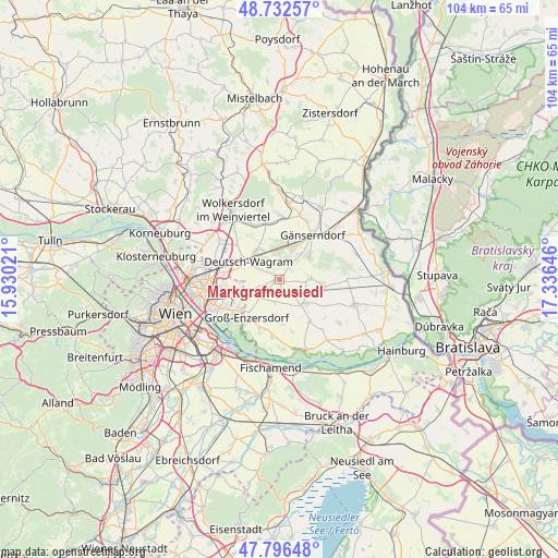
Markgrafneusiedl GPS coordinates[2]
48° 16' 0.012" North, 16° 37' 59.988" East
| Map corner | latitude | longitude |
|---|---|---|
| Upper-left | 48.73257°, | 15.93021° |
| Center: | 48.26667°, | 16.63333° |
| Lower-right: | 47.79648°, | 17.33646° |
| Map W x H: | 104.1×104.1 km | = 64.7×64.7mi |
| max Lat: | 48.98333° ⇑16.2% North |
| Markgrafneusiedl: | 48.26667° |
| min Lat: | ⇓83.8% South 46.48841° |
| min Long | Markgrafneusied | max Long |
| 9.57802° | 16.63333° | 17.1° |
| W 96.4%⇐ | ⇒3.6% E |
Elevation
Elevation of Markgrafneusiedl is 150 m = 492 ft, and this is 355.5 m = 1166 ft below average elevation for this country.
| Max E: |
2140 m = 7021 ft | 98.4% |
| Avg. | 505.5 m = 1658 ft | |
| Markgrafneusiedl | 150 m = 492 ft | |
Min E: |
118 m = 387 ft | 1.6% |
See also: Austria elevation on elevation.city.
Geographical zone
Markgrafneusiedl is located in North temperate zone (between Tropic of Cancer and the Arctic Circle). Distance of this North polar circle is 2034.4 km =1264.1 mi to North.| Distance of | km | miles | from Markgrafneusiedl |
|---|---|---|---|
| North Pole | 4640.3 | 2883.3 | to North |
| Arctic Circle | 2034.4 | 1264.1 | to North |
| Tropic Cancer | 2760.8 | 1715.5 | to South |
| Equator | 5366.8 | 3334.8 | to South |


Nearby cities:
15 places around Markgrafneusiedl: (largest is in red/bold)
• Aderklaa
7.6 km =4.7 mi,  284°
284°
• Andlersdorf
9.6 km =6 mi,  165°
165°
• Deutsch-Wagram
6.2 km =3.9 mi,  306°
306°
• Glinzendorf
2.4 km =1.5 mi, 166°
• Groß-Enzersdorf
9.4 km =5.8 mi,  220°
220°
• Großhofen
1.4 km =0.9 mi,  228°
228°
• Gänserndorf
10.3 km =6.4 mi,  38°
38°
• Leopoldsdorf im Marchfelde
6.4 km =4 mi,  140°
140°
• Oberhausen
10.6 km =6.6 mi,  199°
199°
• Obersiebenbrunn
5.7 km =3.5 mi,  91°
91°
• Parbasdorf
3.1 km =1.9 mi, 306°
• Raasdorf
5.5 km =3.4 mi,  246°
246°
• Strasshof an der Nordbahn
6.1 km =3.8 mi,  23°
23°
• Untersiebenbrunn
7.6 km =4.7 mi,  104°
104°
• Wittau
9.8 km =6.1 mi, 195°
Sources, notices
• [Note1] Compared only with cities in Austria existing in our database
• [Src1] Map data: © OpenStreetMap contributors (CC-BY-SA)
• [Src2] Other city data from geonames.org with taken over terms of usage.
• [Src3] Geographical zone / Annual Mean Temperature by Robert A. Rohde @ Wikipedia
