Aderklaa geodata
Aderklaa (Lower Austria) is a seat of a third-order administrative division; located in Austria in Europe/Vienna (GMT+2) time zone. With population of 207 people, there are 2846 cities with bigger population in this country. Compared to other cities in Austria, 84.8% of cities are located further ↓South; 94.7% of cities are located further ←West and 98% of cities have higher elevation than Aderklaa. Note1
Administrative division(s):
- Level 1: Lower Austria
- Level 2: Politischer Bezirk Gänserndorf
- Level 3: Aderklaa


Aderklaa GPS coordinates[2]
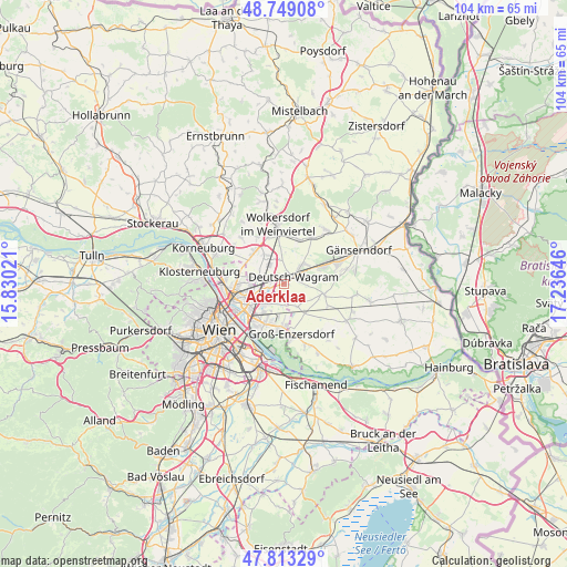
48° 16' 59.988" North, 16° 31' 59.988" East
| Map corner | latitude | longitude |
|---|---|---|
| Upper-left | 48.74908°, | 15.83021° |
| Center: | 48.28333°, | 16.53333° |
| Lower-right: | 47.81329°, | 17.23646° |
| Map W x H: | 104.1×10⁴ km | = 64.7×64.6mi |
| max Lat: | 48.98333° ⇑15.2% North |
| Aderklaa: | 48.28333° |
| min Lat: | ⇓84.8% South 46.48841° |
| min Long | Aderklaa | max Long |
| 9.57802° | 16.53333° | 17.1° |
| W 94.7%⇐ | ⇒5.3% E |
Elevation
Elevation of Aderklaa is 154 m = 505 ft, and this is 351.5 m = 1153 ft below average elevation for this country.
| Max E: |
2140 m = 7021 ft | 98% |
| Avg. | 505.5 m = 1658 ft | |
| Aderklaa | 154 m = 505 ft | |
Min E: |
118 m = 387 ft | 2% |
See also: Austria elevation on elevation.city.
Geographical zone
Aderklaa is located in North temperate zone (between Tropic of Cancer and the Arctic Circle). Distance of this North polar circle is 2032.6 km =1263 mi to North.| Distance of | km | miles | from Aderklaa |
|---|---|---|---|
| North Pole | 4638.5 | 2882.2 | to North |
| Arctic Circle | 2032.6 | 1263 | to North |
| Tropic Cancer | 2762.7 | 1716.7 | to South |
| Equator | 5368.6 | 3335.9 | to South |


Nearby cities:
15 places around Aderklaa: (largest is in red/bold)
• Bockfließ
10 km =6.2 mi,  31°
31°
• Deutsch-Wagram
3.1 km =1.9 mi,  53°
53°
• Donaustadt
7.8 km =4.8 mi,  224°
224°
• Gerasdorf bei Wien
5 km =3.1 mi,  284°
284°
• Glinzendorf
9 km =5.6 mi,  117°
117°
• Groß-Engersdorf
8.7 km =5.4 mi,  16°
16°
• Groß-Enzersdorf
9 km =5.6 mi,  171°
171°
• Großebersdorf
10.1 km =6.3 mi,  332°
332°
• Großhofen
6.9 km =4.3 mi,  113°
113°
• Markgrafneusiedl
7.6 km =4.7 mi,  104°
104°
• Obersdorf
9.3 km =5.8 mi,  352°
352°
• Parbasdorf
4.9 km =3 mi,  90°
90°
• Pillichsdorf
7.4 km =4.6 mi,  0°
0°
• Raasdorf
4.7 km =2.9 mi,  149°
149°
• Seyring
6.7 km =4.2 mi, 326°
Sources, notices
• [Note1] Compared only with cities in Austria existing in our database
• [Src1] Map data: © OpenStreetMap contributors (CC-BY-SA)
• [Src2] Other city data from geonames.org with taken over terms of usage.
• [Src3] Geographical zone / Annual Mean Temperature by Robert A. Rohde @ Wikipedia
