Mariapfarr geodata
Mariapfarr (Salzburg) is a seat of a third-order administrative division; located in Austria in Europe/Vienna (GMT+2) time zone. With population of 1,612 people, there are 776 cities with bigger population in this country. Compared to other cities in Austria, 76% of cities are located further ↑North; 70.4% of cities are located further →East and 96.8% of cities have lower elevation than Mariapfarr. Note1
Administrative division(s):
- Level 1: Salzburg
- Level 2: Politischer Bezirk Tamsweg
- Level 3: Mariapfarr


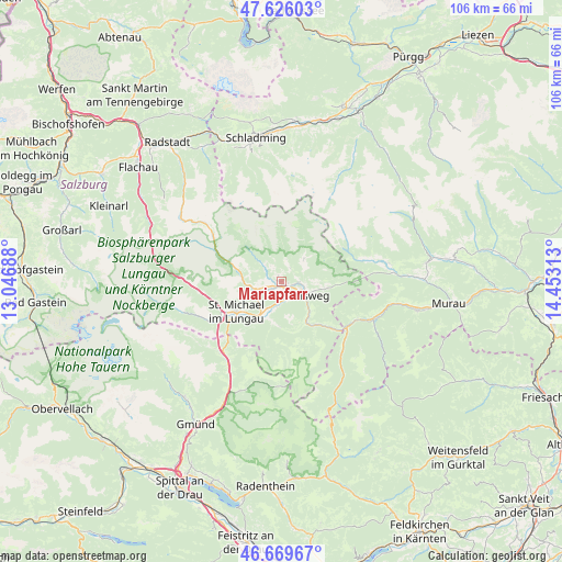
Mariapfarr GPS coordinates[2]
47° 9' 0" North, 13° 45' 0" East
| Map corner | latitude | longitude |
|---|---|---|
| Upper-left | 47.62603°, | 13.04688° |
| Center: | 47.15°, | 13.75° |
| Lower-right: | 46.66967°, | 14.45313° |
| Map W x H: | 106.3×106.3 km | = 66.1×66.1mi |
| max Lat: | 48.98333° ⇑76% North |
| Mariapfarr: | 47.15° |
| min Lat: | ⇓24% South 46.48841° |
| min Long | Mariapfarr | max Long |
| 9.57802° | 13.75° | 17.1° |
| W 29.6%⇐ | ⇒70.4% E |
Elevation
Elevation of Mariapfarr is 1115 m = 3658 ft, and this is 609.5 m = 2000 ft above average elevation for this country.
| Max E: |
2140 m = 7021 ft | 3.2% |
| Mariapfarr | 1115 m 3658 ft | |
| Avg. | 505.5 m = 1658 ft | |
Min E: |
118 m = 387 ft | 96.8% |
See also: Austria elevation on elevation.city.
Geographical zone
Mariapfarr is located in North temperate zone (between Tropic of Cancer and the Arctic Circle). Distance of this North polar circle is 2158.6 km =1341.3 mi to North.| Distance of | km | miles | from Mariapfarr |
|---|---|---|---|
| North Pole | 4764.5 | 2960.5 | to North |
| Arctic Circle | 2158.6 | 1341.3 | to North |
| Tropic Cancer | 2636.7 | 1638.4 | to South |
| Equator | 5242.6 | 3257.6 | to South |


Nearby cities:
15 places around Mariapfarr: (largest is in red/bold)
• Krakauhintermühlen
18 km =11.2 mi,  78°
78°
• Krakauschatten
16.8 km =10.4 mi, 77°
• Mauterndorf
5.7 km =3.5 mi,  252°
252°
• Mörtelsdorf
3.7 km =2.3 mi,  128°
128°
• Ramingstein
10.6 km =6.6 mi,  142°
142°
• Rennweg am Katschberg
17.9 km =11.1 mi,  214°
214°
• Sankt Andrä im Lungau
2.5 km =1.6 mi,  90°
90°
• Sankt Margarethen im Lungau
8.9 km =5.5 mi, 207°
• Sankt Martin
9.4 km =5.8 mi,  233°
233°
• Sankt Michael im Lungau
10.4 km =6.5 mi,  237°
237°
• Stadl an der Mur
18 km =11.2 mi,  114°
114°
• Tamsweg
5.2 km =3.2 mi,  117°
117°
• Thomatal
9.3 km =5.8 mi,  180°
180°
• Tweng
11.9 km =7.4 mi,  288°
288°
• Unternberg
4.2 km =2.6 mi,  187°
187°
Sources, notices
• [Note1] Compared only with cities in Austria existing in our database
• [Src1] Map data: © OpenStreetMap contributors (CC-BY-SA)
• [Src2] Other city data from geonames.org with taken over terms of usage.
• [Src3] Geographical zone / Annual Mean Temperature by Robert A. Rohde @ Wikipedia
