Unternberg geodata
Unternberg (Salzburg) is a populated place; located in Austria in Europe/Vienna (GMT+2) time zone. With population of 1,035 people, there are 1235 cities with bigger population in this country. Compared to other cities in Austria, 78.5% of cities are located further ↑North; 70.5% of cities are located further →East and 95% of cities have lower elevation than Unternberg. Note1
Administrative division(s):
- Level 1: Salzburg
- Level 2: Politischer Bezirk Tamsweg
- Level 3: Unternberg


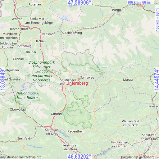
Unternberg GPS coordinates[2]
47° 6' 45.684" North, 13° 44' 33.396" East
| Map corner | latitude | longitude |
|---|---|---|
| Upper-left | 47.58906°, | 13.03949° |
| Center: | 47.11269°, | 13.74261° |
| Lower-right: | 46.63202°, | 14.44574° |
| Map W x H: | 106.4×106.4 km | = 66.1×66.1mi |
| max Lat: | 48.98333° ⇑78.5% North |
| Unternberg: | 47.11269° |
| min Lat: | ⇓21.5% South 46.48841° |
| min Long | Unternberg | max Long |
| 9.57802° | 13.74261° | 17.1° |
| W 29.5%⇐ | ⇒70.5% E |
Elevation
Elevation of Unternberg is 1022 m = 3353 ft, and this is 516.5 m = 1695 ft above average elevation for this country.
| Max E: |
2140 m = 7021 ft | 5% |
| Unternberg | 1022 m 3353 ft | |
| Avg. | 505.5 m = 1658 ft | |
Min E: |
118 m = 387 ft | 95% |
See also: Austria elevation on elevation.city.
Geographical zone
Unternberg is located in North temperate zone (between Tropic of Cancer and the Arctic Circle). Distance of this North polar circle is 2162.7 km =1343.8 mi to North.| Distance of | km | miles | from Unternberg |
|---|---|---|---|
| North Pole | 4768.6 | 2963.1 | to North |
| Arctic Circle | 2162.7 | 1343.8 | to North |
| Tropic Cancer | 2632.5 | 1635.8 | to South |
| Equator | 5238.4 | 3255 | to South |


Nearby cities:
15 places around Unternberg: (largest is in red/bold)
• Mariapfarr
4.2 km =2.6 mi,  7°
7°
• Mauterndorf
5.4 km =3.4 mi,  296°
296°
• Muhr
18.6 km =11.6 mi,  265°
265°
• Mörtelsdorf
3.9 km =2.4 mi,  61°
61°
• Ramingstein
8.3 km =5.2 mi,  120°
120°
• Rennweg am Katschberg
14.3 km =8.9 mi,  221°
221°
• Sankt Andrä im Lungau
5.2 km =3.2 mi,  36°
36°
• Sankt Margarethen im Lungau
5.1 km =3.2 mi, 223°
• Sankt Martin
7.1 km =4.4 mi,  258°
258°
• Sankt Michael im Lungau
8.4 km =5.2 mi, 260°
• Stadl an der Mur
17.3 km =10.7 mi,  100°
100°
• Tamsweg
5.5 km =3.4 mi,  71°
71°
• Thomatal
5.1 km =3.2 mi,  173°
173°
• Tweng
13.3 km =8.3 mi,  306°
306°
• Zederhaus
18.5 km =11.5 mi,  284°
284°
Sources, notices
• [Note1] Compared only with cities in Austria existing in our database
• [Src1] Map data: © OpenStreetMap contributors (CC-BY-SA)
• [Src2] Other city data from geonames.org with taken over terms of usage.
• [Src3] Geographical zone / Annual Mean Temperature by Robert A. Rohde @ Wikipedia
