Mauterndorf geodata
Mauterndorf (Salzburg) is a seat of a third-order administrative division; located in Austria in Europe/Vienna (GMT+2) time zone. With population of 1,261 people, there are 1001 cities with bigger population in this country. Compared to other cities in Austria, 76.7% of cities are located further ↑North; 71.7% of cities are located further →East and 97.1% of cities have lower elevation than Mauterndorf. Note1
Administrative division(s):
- Level 1: Salzburg
- Level 2: Politischer Bezirk Tamsweg
- Level 3: Mauterndorf


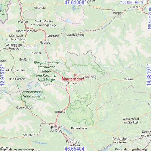
Mauterndorf GPS coordinates[2]
47° 8' 4.236" North, 13° 40' 43.824" East
| Map corner | latitude | longitude |
|---|---|---|
| Upper-left | 47.61068°, | 12.97572° |
| Center: | 47.13451°, | 13.67884° |
| Lower-right: | 46.65404°, | 14.38197° |
| Map W x H: | 106.4×106.4 km | = 66.1×66.1mi |
| max Lat: | 48.98333° ⇑76.7% North |
| Mauterndorf: | 47.13451° |
| min Lat: | ⇓23.3% South 46.48841° |
| min Long | Mauterndorf | max Long |
| 9.57802° | 13.67884° | 17.1° |
| W 28.3%⇐ | ⇒71.7% E |
Elevation
Elevation of Mauterndorf is 1128 m = 3701 ft, and this is 622.5 m = 2042 ft above average elevation for this country.
| Max E: |
2140 m = 7021 ft | 2.9% |
| Mauterndorf | 1128 m 3701 ft | |
| Avg. | 505.5 m = 1658 ft | |
Min E: |
118 m = 387 ft | 97.1% |
See also: Austria elevation on elevation.city.
Geographical zone
Mauterndorf is located in North temperate zone (between Tropic of Cancer and the Arctic Circle). Distance of this North polar circle is 2160.3 km =1342.3 mi to North.| Distance of | km | miles | from Mauterndorf |
|---|---|---|---|
| North Pole | 4766.2 | 2961.6 | to North |
| Arctic Circle | 2160.3 | 1342.3 | to North |
| Tropic Cancer | 2634.9 | 1637.3 | to South |
| Equator | 5240.9 | 3256.5 | to South |


Nearby cities:
15 places around Mauterndorf: (largest is in red/bold)
• Krakauschatten
22.4 km =13.9 mi,  75°
75°
• Mariapfarr
5.7 km =3.5 mi,  72°
72°
• Muhr
14.3 km =8.9 mi,  253°
253°
• Mörtelsdorf
8.3 km =5.2 mi,  93°
93°
• Ramingstein
13.7 km =8.5 mi,  119°
119°
• Rennweg am Katschberg
13.9 km =8.6 mi,  199°
199°
• Sankt Andrä im Lungau
8.1 km =5 mi, 77°
• Sankt Margarethen im Lungau
6.3 km =3.9 mi,  167°
167°
• Sankt Martin
4.4 km =2.7 mi,  209°
209°
• Sankt Michael im Lungau
5.2 km =3.2 mi,  221°
221°
• Tamsweg
10 km =6.2 mi, 94°
• Thomatal
9.3 km =5.8 mi,  144°
144°
• Tweng
8.1 km =5 mi,  312°
312°
• Unternberg
5.4 km =3.4 mi, 116°
• Zederhaus
13.3 km =8.3 mi,  280°
280°
Sources, notices
• [Note1] Compared only with cities in Austria existing in our database
• [Src1] Map data: © OpenStreetMap contributors (CC-BY-SA)
• [Src2] Other city data from geonames.org with taken over terms of usage.
• [Src3] Geographical zone / Annual Mean Temperature by Robert A. Rohde @ Wikipedia
