Mannersdorf an der Rabnitz geodata
Mannersdorf an der Rabnitz (Burgenland) is a seat of a third-order administrative division; located in Austria in Europe/Vienna (GMT+2) time zone. With population of 568 people, there are 2254 cities with bigger population in this country. Compared to other cities in Austria, 57.7% of cities are located further ↑North; 94.5% of cities are located further ←West and 86.4% of cities have higher elevation than Mannersdorf an der Rabnitz. Note1
Administrative division(s):
- Level 1: Burgenland
- Level 2: Politischer Bezirk Oberpullendorf
- Level 3: Mannersdorf an der Rabnitz
Current local time in Mannersdorf an der Rabnitz:
11:52 PM, FridayDifference from your time zone: hours


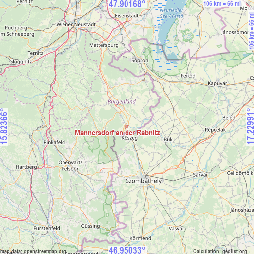
Mannersdorf an der Rabnitz GPS coordinates[2]
47° 25' 41.34" North, 16° 31' 36.408" East
| Map corner | latitude | longitude |
|---|---|---|
| Upper-left | 47.90168°, | 15.82366° |
| Center: | 47.42815°, | 16.52678° |
| Lower-right: | 46.95033°, | 17.22991° |
| Map W x H: | 105.8×105.8 km | = 65.7×65.7mi |
| max Lat: | 48.98333° ⇑57.7% North |
| Mannersdorf an der Rabnitz: | 47.42815° |
| min Lat: | ⇓42.3% South 46.48841° |
| min Long | Mannersdorf an | max Long |
| 9.57802° | 16.52678° | 17.1° |
| W 94.5%⇐ | ⇒5.5% E |
Elevation
Elevation of Mannersdorf an der Rabnitz is 239 m = 784 ft, and this is 266.5 m = 874 ft below average elevation for this country.
| Max E: |
2140 m = 7021 ft | 86.4% |
| Avg. | 505.5 m = 1658 ft | |
| Mannersdorf an der Rabnitz | 239 m = 784 ft | |
Min E: |
118 m = 387 ft | 13.6% |
See also: Austria elevation on elevation.city.
Geographical zone
Mannersdorf an der Rabnitz is located in North temperate zone (between Tropic of Cancer and the Arctic Circle). Distance of this North polar circle is 2127.7 km =1322.1 mi to North.| Distance of | km | miles | from Mannersdorf an der Rabnitz |
|---|---|---|---|
| North Pole | 4733.5 | 2941.3 | to North |
| Arctic Circle | 2127.7 | 1322.1 | to North |
| Tropic Cancer | 2667.6 | 1657.6 | to South |
| Equator | 5273.5 | 3276.8 | to South |


Nearby cities:
15 places around Mannersdorf an der Rabnitz: (largest is in red/bold)
• Drassmarkt
13.7 km =8.5 mi,  315°
315°
• Dörfl im Burgenland
7 km =4.3 mi,  331°
331°
• Grosswarasdorf
12.5 km =7.8 mi,  9°
9°
• Lockenhaus
8.6 km =5.3 mi,  254°
254°
• Lutzmannsburg
9.2 km =5.7 mi,  64°
64°
• Mitterpullendorf
7.3 km =4.5 mi,  356°
356°
• Neutal
14.4 km =8.9 mi,  335°
335°
• Oberloisdorf
2.6 km =1.6 mi, 326°
• Oberpullendorf
8.5 km =5.3 mi,  348°
348°
• Pilgersdorf
13.4 km =8.3 mi,  276°
276°
• Piringsdorf
8.7 km =5.4 mi, 284°
• Rechnitz
15.2 km =9.4 mi,  205°
205°
• Steinberg an der Rabnitz
5.9 km =3.7 mi, 330°
• Stoob
11.7 km =7.3 mi, 341°
• Unterrabnitz
11.6 km =7.2 mi, 284°
Sources, notices
• [Note1] Compared only with cities in Austria existing in our database
• [Src1] Map data: © OpenStreetMap contributors (CC-BY-SA)
• [Src2] Other city data from geonames.org with taken over terms of usage.
• [Src3] Geographical zone / Annual Mean Temperature by Robert A. Rohde @ Wikipedia
