Oberloisdorf geodata
Oberloisdorf (Burgenland) is a seat of a third-order administrative division; located in Austria in Europe/Vienna (GMT+2) time zone. With population of 806 people, there are 1602 cities with bigger population in this country. Compared to other cities in Austria, 56.8% of cities are located further ↑North; 94.1% of cities are located further ←West and 84.9% of cities have higher elevation than Oberloisdorf. Note1
Administrative division(s):
- Level 1: Burgenland
- Level 2: Politischer Bezirk Oberpullendorf
- Level 3: Oberloisdorf


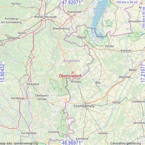
Oberloisdorf GPS coordinates[2]
47° 26' 50.496" North, 16° 30' 27.504" East
| Map corner | latitude | longitude |
|---|---|---|
| Upper-left | 47.92071°, | 15.80452° |
| Center: | 47.44736°, | 16.50764° |
| Lower-right: | 46.96971°, | 17.21077° |
| Map W x H: | 105.7×105.7 km | = 65.7×65.7mi |
| max Lat: | 48.98333° ⇑56.8% North |
| Oberloisdorf: | 47.44736° |
| min Lat: | ⇓43.2% South 46.48841° |
| min Long | Oberloisdorf | max Long |
| 9.57802° | 16.50764° | 17.1° |
| W 94.1%⇐ | ⇒5.9% E |
Elevation
Elevation of Oberloisdorf is 247 m = 810 ft, and this is 258.5 m = 848 ft below average elevation for this country.
| Max E: |
2140 m = 7021 ft | 84.9% |
| Avg. | 505.5 m = 1658 ft | |
| Oberloisdorf | 247 m = 810 ft | |
Min E: |
118 m = 387 ft | 15.1% |
See also: Austria elevation on elevation.city.
Geographical zone
Oberloisdorf is located in North temperate zone (between Tropic of Cancer and the Arctic Circle). Distance of this North polar circle is 2125.5 km =1320.7 mi to North.| Distance of | km | miles | from Oberloisdorf |
|---|---|---|---|
| North Pole | 4731.4 | 2940 | to North |
| Arctic Circle | 2125.5 | 1320.7 | to North |
| Tropic Cancer | 2669.7 | 1658.9 | to South |
| Equator | 5275.7 | 3278.2 | to South |


Nearby cities:
15 places around Oberloisdorf: (largest is in red/bold)
• Drassmarkt
11.2 km =7 mi,  313°
313°
• Dörfl im Burgenland
4.4 km =2.7 mi,  335°
335°
• Grosswarasdorf
10.8 km =6.7 mi,  18°
18°
• Lockenhaus
8.2 km =5.1 mi,  237°
237°
• Lutzmannsburg
9.9 km =6.2 mi,  79°
79°
• Mannersdorf an der Rabnitz
2.6 km =1.6 mi,  146°
146°
• Mitterpullendorf
5.2 km =3.2 mi,  11°
11°
• Neutal
11.8 km =7.3 mi, 337°
• Oberpullendorf
6.2 km =3.9 mi,  357°
357°
• Pilgersdorf
11.9 km =7.4 mi,  266°
266°
• Piringsdorf
7 km =4.3 mi, 270°
• Steinberg an der Rabnitz
3.3 km =2.1 mi,  333°
333°
• Stoob
9.3 km =5.8 mi,  345°
345°
• Unterrabnitz
9.9 km =6.2 mi, 274°
• Weingraben
13.1 km =8.1 mi,  304°
304°
Sources, notices
• [Note1] Compared only with cities in Austria existing in our database
• [Src1] Map data: © OpenStreetMap contributors (CC-BY-SA)
• [Src2] Other city data from geonames.org with taken over terms of usage.
• [Src3] Geographical zone / Annual Mean Temperature by Robert A. Rohde @ Wikipedia
